


|
||

|

|
|

|
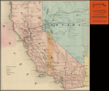
Rare large foldng map of California, with a map of the Los Angeles Basin on the verso.
The map of California is divided into counties, and includes the newly formed Imperial County, along with the route of the Los Angeles Aqueduct in red, noting the location of the Fernandon Reservoir and the Fairmount Reservoir, along with the intake point and its eleveantion, north of Independence, California.
The map is embellished with a large vignette of the Los Angeles Trust and Savings Bank at Sixth and Spring Street.
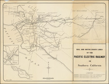
The map of the Los Angeles Basin, printed in red, extends to Winchester, Hemet and San Jacinto in the southeast, the San Bernardino Mountains and Beaumont in the northeast and Newport Beach and Balboa in the South. A legend notes the exisitng and proposed rail lines in the Los Angeles Basin.
The LA Basin map is 24.5 x 20.5
![[Appointment of Ben E.S. Ely as Notary Public for Napa County, California - September 26, 1861]](https://storage.googleapis.com/raremaps/img/small/93309.jpg)