


|
||

|

|
|

|
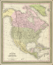
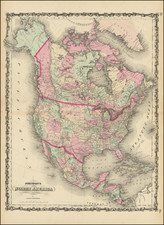
Fantastic Early Depiction of the Transmississippi West, including the Madison, Jefferson and Gallatin Rivers in the Pacific Northwest.
Scarce map of North America, published shortly after the Louisiana Purchase and immediately after the return of Lewis & Clark from their overland journey to the Northwest.
The map provides a fascinating depiction of the Transmississippi West, with very few mountain ranges and a wishful but elusive search for a simple watercourse from the Missouri to the Pacific, with hints of short portages across relatively minor Pacific Coastal Ranges.
The map shows the Upper Missouri and its tributaries in a fascinating detail, with the Madison, Jefferson and Gallatin rivers nearly reaching the Pacific Ocean, clearly a bit prior to the first view of Lewis & Clark's official account and map.
The map is rich with Indian detail in both the Transmississippi West and the Missouri and Mississippi Valleys. The discoveries of the Hudson Bay Company and the trading houses established in the late 18th and early 19th Centuries are much better documented, with dates of exploration, dozens of trading houses located and other notes. The map includes nice post-Vancouver, post-La Perouse information along the Northwest and California Coastlines.
Includes a large inset map of Alaska.
![Oceani Occidentalis Seu Terrae Novae Tabula [The Admiral's Map]](https://storage.googleapis.com/raremaps/img/small/102935.jpg)