This item has been sold, but you can enter your email address to be notified if another example becomes available.


|
||

|

|
|

|
Stock# 46849
Description
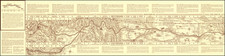
Finely executed map of a portion of the "Proposed Great Continental Railroad" and environs, focused on the South Pass portion of the Oregon Trail.
The map extends west to the Great Salt Lake and Fort Hall, tracking the course of the Snake River, Bear River, Green River, Wind River and the North Platte to their sources in the mountains of southwestern Wyoming and northeastern Utah.
![[Utah] Amer. Sep. No. 47. Partie Du Mexique](https://storage.googleapis.com/raremaps/img/small/88711.jpg)
![[Mormon Trail] Utah And the Overland Routes to it, from the Missouri River: Published with](https://storage.googleapis.com/raremaps/img/small/66366.jpg)
![[ Used by '49ers To Travel To California ] Map of Oregon and Upper California from the surveys of John Charles Fremont and others authorities drawn by Charles Preuss 1848](https://storage.googleapis.com/raremaps/img/small/100557.jpg)