


|
||

|

|
|

|
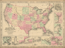
With Distortions Intended To Favor Competing Railroad Lines
Fascinating Railroad Promotional Map of the United States, printed by Rand McNally for the Chicago, Burlington & Quincy Railroad.
The present map includes a text panel at the bottom, specifically intended to promote the route to "Passengers from San Francisco." While other editions of this map exist, this is the only edition which we have located that targets the California market.
The map is perhaps most famous for utilizing distrortions to suggest that the lines of the Burlington Route were shorter than its competitors routes, as describe by Woodward. Warren Heckrotte notes
There are five scenic views along the R.R. route and four interior views of railroad cars. A panel of text provides information for passengers. Woodward in his book on wax engraving quotes a contemporary letter which singles this map out for criticism for its distortion of distances. These distortions were introduced to favor one railroad route over that of competitors.
Accompanied by a page of the California Spirit of the Times with advertisement for Atchison, Topeka and Santa Fe Railroads, offering Knights Templar three routes to California.
The map is quite rare on the market, especially in such fine condition.
Provenance: Warren Heckrotte, acquired from the Holmes Book Company of Oakland, in 1975.
Rand McNally & Co. is a large American map and navigation company best known for its annual atlases. The company got its start in 1856, when William Rand opened a print shop in Chicago. He was joined in 1858 by a new employee, Andrew McNally. Together, the men established their namesake company in 1868. Originally, the company was intended to print the tickets and timetables for the trains running to and through Chicago; their first railway guide was published in 1869.
By 1870, they had shifted from just printing to publishing directories, travel guides, and newspapers. Their first map appeared in 1872 in a railway guide. The map was produced using a new wax engraving method, a cheaper process that gave the company an edge.
By 1880 Rand McNally had entered the education market with globes, wall maps, and geography texts for students. In 1923, Rand McNally published the first Goode’s World Atlas, named after its editor, Dr. J. Paul Goode. For generations afterward, this would be the standard classroom atlas.
In 1899, William Rand left the company, but McNally and his family remained, controlling the company for over a century. In 1904, they published their first road map intended for automobiles and by 1907 were publishing Photo-Auto Guides, which combined photography and mapping to help drivers. In 1924, they produced the Auto Chum, a precursor to their famous road atlases. Rand McNally would remain the leader in road maps and atlases throughout the twentieth century.
In 1937, Rand McNally opened its first store in New York City. Ever on the frontier of technology, Rand McNally pioneered the scribing process for printing tickets in 1958 and printed their first full-color road atlas in 1960. Arthur Robinson developed his now-famous projection of Rand McNally in 1969. By the 1980s, the company was exploring digital reproduction and digital databases of maps for truckers. In the 1990s, they lead the charge to develop trip-planning software and websites. Today, most of its products are available online or in a digital format, including maps for tablets and phones.

![[ Southern Railroads ] Railroad Map of the Southern States Shewing the Southern & Southwestern Railway Connections With Philadelphia. 1862 . . . Prepared by Thomas Kimber Jr., Chairman of the Committee on Inland Transportation of the Board of Trade of Philadelphia](https://storage.googleapis.com/raremaps/img/small/103211.jpg)
