


|
||

|

|
|

|
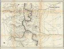
Second official map of Colorado Territory, based upon state surveys conducted by the General Land Office, in Denver City, in September of 1862.
The Gold Bearing Region is prominently depicted, along with some early mining towns, including Centre City, Idaho, Empire, Breckinridge, Fairplay, Oro City, Tarryall, Hamilton and Lauret.
The map shows the early territorial surveys, an early regional depiction of the Rockies with early place names, the Cheyenne and Arapahoe Reservations, rivers, mountains, Bent's Fort, Colorado City, Denver, Henderson's Ranch, Ft. St. Vrain, Golden City, Central City, Bradford, Hamilton, Jefferson, Ft. Garland, Gagosa, and handful of other place names.
The 1862 map is the second appearance of the territory among the maps of the General Land Office. Colorado Territory was organized in the wake of the 1859 Colorado Gold Rush, which had brought the first large influx of white settlement into the region. Congress passed the organic act for the territory, in the spring of 1861, in the midest of the secessions by Southern states that precipitated the Civil War. The organization of Colorado Territory was promoted to solidify Union control over a mineral-rich area of the Rocky Mountains.
Wheat calls this map a "credible effort" and notes the following new information: "The Eagle Tail River has now become the Gunnison. . . . On the upper Colorado, called 'Grand River,' the former Bunkara Creek appears as Roaring Fork. White River in northwestern Colorado is represented much more correctly; and new peaks are shown, including Elk Head Mt., Clarmont, Rabbit Ears, Sopris Peak, and Dome Peak. A number of new mining camps and settlements are located, but none west of the Continental Divide." The map also shows townships under contract for subdivision south along the Denver corridor, townships proposed to be subdivided, and great topographical relief for the Front Range. The South Platte and Arkansas Rivers feature prominently.
One of the earliest obtainable maps of Colorado Territory and far superior to the 1861 edition of this map in terms of details.
The General Land Office (GLO) refers to the independent agency in the United States that was in charge of public domain lands. Created in 1812, it assumed the responsibilities for public domain lands from the United States Department of the Treasury. The Treasury had overseen the survey of the Northwest Territory, but as more area was added to the United States, a new agency was necessary to survey the new lands.
Eventually, the GLO would be responsible for the surveying, platting, and sale of the majority of the land west of the Mississippi, with the exception of Texas. When the Secretary of the Interior was created in 1849, the GLO was placed under its authority. Until the creation of the Forest Service in 1905, the GLO also managed forest lands that had been removed from public domain. In additional to managing the fees and sales of land, the GLO produced maps and plans of the areas and plots they surveyed. In 1946, the GLO merged with the United States Grazing Service to become the Bureau of Land Management.
![[ Upper California ] Map of the Californias By T.J. Farnham](https://storage.googleapis.com/raremaps/img/small/99592.jpg)
![Map of Mexico, Central America, and the West Indies [Insets of Bermuda, Cuba, Jamaica and Panama Railroad]](https://storage.googleapis.com/raremaps/img/small/70686.jpg)
![[ Used by '49ers To Travel To California ] Map of Oregon and Upper California from the surveys of John Charles Fremont and others authorities drawn by Charles Preuss 1848](https://storage.googleapis.com/raremaps/img/small/100557.jpg)