|
||

|

|
|

|
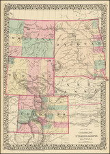
A Western Rarity -- Proof State of the GK Warren Map of Nebraska and Dakota Territories, Signed By William Merrill
Proof state of the unrecorded second state of Governour Kemble Warren's large format map of Kansas, Nebraska, Dakota and part Colorado and Wyoming, based upon surveys and reconnaissance expeditions conducted between 1836 and 1864.
This map is a treasure trove of information, which includes manuscript annotations of an expedition to Chief Black Moon's Encampment on the Little Missouri, as well as to a number of newly constructed Forts on the Overland Trail (Fort Stevenson and Fort Totten, among others), quite likely in connection with the construction of these forts between 1867 and 1868.
G.K. Warren's Map and Its Various States
Warren's extensive knowledge of the area and his great skills as a cartographer are obvious in this large, highly detailed map. It shows the topographic and geographic features from Kansas in the south to the Canadian border on the north, and extends westward to the eastern edge of the Colorado Rockies and beyond the fork of the Yellowstone and Missouri Rivers.
The first edition of the map was first completed in 1858, and is very rare on the market. It accompanied Warren's study of the Black Hills, and the Nebraska and Dakota regions, published as an appendix to General Andrew A. Humphreys' Report of the War Department to the President (1858).
However, unlike the other known states, which were produced by the Government Printing Office in Washington, D.C., the present map was published by Julius Bien in New York. Bien, one of America's leading lithographers, was frequently contracted by the federal government to print important maps and publications with advanced graphic content. The great rarity of the map may be accounted for the fact that it was part of a trial print run that was discontinued, leaving this solitary example.
This state of the map was likely prepared specifically for field use and issued to key officers during the period that William E. Merrill was commanding officer of the Department of the Missouri. We are aware of other examples of similar rare Western maps having been re-purposed by Merrill and periodically updated during this period and in fact the only other known example of this state of the map was bore the inscription reflecting that it had been disseminated by Merrill.
We have identified two distinguishing factors on this state of the map which are not present on other states which make for ready identification:
- A credit to Bien at the bottom left of the map, below the neatline
- The location of the last line of text above the scale of miles is centered. This list appears in the present format only in the second state of the map. In later dates, the last line is left justified to match the lines above it.
Moreover, the present example of the map is apparently a proof state of the map. Unlike the example of this map we offered in 2012, this state includes a number of changes not present in the second state:
- Omaha City is shown, with a small town grid, opposite Council Bluff
- Ft. Wadsworth appears, mislocated roughly 20-40 miles south of its location on the final map.
- Ft. Bufford appears at the confluence of the Yellowstone and Missouri Rivers
- Two Ft. Sully's appear. The first is "Old Fort Sully," below Ft. Pierce. A second Ft. Sully appears north of Okuboju Creek, which is not on the second state.
- Ft. Wallace, Ft. Hays and Ft. Harker appears on the Smoky Hill Fork
- Ft. Sanders appears on the Laramy River, northwest of Camp Collins and west of the Cheyenne Pass. On the second state, the fort is identified as Fort J. Buford.
- Ft. Thompson is added, north of Ft. Lookout.
The following is a link to the second state of the map: /gallery/detail/34495mb
Fort Wadsworth, a US Military post to further strengthen and protect the Dakota Territory was built in 1864 at the head of the Coteau de Prairies, on the south side of Kettle Lakes, in northeastern South Dakota. It became known as Fort Sisseton in August 1876, to honor the friendly Sioux scouts who helped to protect it from direct attack.
Like the 1858 first state, this map features a wealth of historical information, most notably the labeled routes of surveyors, including those working for the Government Land Office, the Pacific Railroad Survey, as well as the military surveyors Stansbury, Fremont, Nicollet, Dickinson, Warren and others. T he territories of the various Native nations, including Indian Reserves, are labeled, betraying the fact that in 1867 the northern Great Plains were in the midst of the Indian Wars. Indeed, the primary intended purpose of this map would have been to serve as an operational guide for U.S. Army officers serving in an active theater. Moreover, numerous forts and settlements are noted, outposts on what was still a wild and unpredictable frontier.
This map is noticeably updated from the 1858 edition. The most important change is the appearance of two lines of the Union Pacific Railroad; one running along the Platte River from Omaha to Denver, the other heading into Wyoming. As the first transcontinental fixed link, the railroad was one of the most transformative innovations in American history. It was commenced heading west from Omaha, and eastwards from Sacramento in 1863. Clearly, much progress had been made by 1867, and the line was completed in 1869.
The present example also features important improvements with respect to the Dakotas. Compared to the 1858 edition, this map features far greater detail as to the delineation of the river systems, and includes the additions of new forts and outposts founded in the 1860s. Much of this intelligence was derived from the respective expeditions of Captain W.F. Reynolds (1859) and General Alfred Sully (1864), of which their routes are marked on the map. Moreover, the lengthy annotation which appeared towards the top center of the 1858 edition, which noted that the boundary between American and British territory (the 49th parallel) had not yet been surveyed, is not featured on this map, presumably because such work had since been undertaken.
It appears that it was Bien's lithographic stones which were later revised to create the third state of the map, the one revised to include Geological features by Dr. Ferdinand Hayden, and published in Washington, D.C. in 1872. The map was also apparently issued in 1869 in Joseph Leidy's The Extinct Mammalian Fauna of Dakota and Nebraska. This Hayden-Warren map was highly influential in that it sparked interest in prospecting in the Black Hills, leading to important discoveries of gold. Four years later, Hayden, then Professor of Geology and Mineralogy at the University of Pennsylvania, would embark on his famous trip of exploration that resulted in Yellowstone becoming the first National Park in the United States. It seems that Julius Bien, who ended up printing many of Hayden's maps, gave the geologist a copy of this map as a basis for his work.
The Manuscript Annotations
The map includes several sets of manuscript annotations. The first set of annotations sets forth modern boundaries, delineating Montana, Colorado and Kansas in its more modern configuration. The failure to show Wyoming, which became a Territory on July 25, 1868. As such, it would seem that the annotations on the map almost certainly fall between June 27, 1868 (the date of Merrill's signature on the map) and July 25, 1868.
The second set of annotations focus on several rivers near the source of the Little Missouri River, near the name "Montana," which were apparently non-existent and intended to be removed in the next edition of the map.
The final set of annotations includes what appears to be the route of an expedition that reached from Fort Buford to Fort Berthold and on to Fort Rice and finally to the future location of Fort Totten on Spirit (Devil's) Lake, Dakota Territory.
Fort Bufford was a US Army Fort at the confluence of the Missouri River and Yellowstone River, which established on June 15, 1866, under the Command of then Captain William G. Rankin. This would be the site of Sitting Bull's Surrender in 1881.
Fort Rice was established on July 7, 1864 by General Alfred H. Sully, as a field base for his 1864 expedition. From 1866 to 1868, it was the site of a number of important Indian Councils with the Sioux Indians. In July 1868, a major peace council was held at Fort Rice which led to the Laramie Treaty which defined Sioux lands as those west of the Missouri River in Dakota Territory.
Fort Totten, Dakota Territory, was established by General Alfred Howe Terry on July 17, 1867, at the time of the establishment of the Devils Lake Sioux Reservation in 1867. The Fort was built to protect the overland route from Southern Minnesota to western Montana, along with Fort Abercrombie, Fort Ransom, Fort Stevenson, Fort Buford and Fort Benton. In 1868, Fort Totten was rebuilt and enlarged.
The map also adds the location, in manuscript, of Fort Stevenson, to east of Fort Berthold. Fort Stevenson was constructed beginning in July of 1867 and completed in 1868. It was abandoned in 1883.
Perhaps of greatest note, the map locates "Black Moon's Camp," at the confluence of the Little Missouri River and a second river (Beaver Creek?) in southwestern Dakota Territory. Black Moon was one of the Principal Sioux Chiefs at the time of the 1868 Fort Laramie Treaty, who along with Sitting Bull chose not to relocate to a reservation. He is also one of the Sioux Chiefs who met with Father De Smet in June 1868. Black Moon would later die at Custer's Massacre of June 25, 1876.
Gouverneur Kemble Warren
Gouverneur Kemble Warren (1830 - 1882) was a civil engineer, who served as General in the Union Army during the American Civil War. After graduating from the US Military Academy, he was commissioned a brevet second lieutenant in the Corps of Topographical Engineers. From 1850 to 1853, Warren served on several important survey expeditions, including surveys of the lower Mississippi delta in 1850-1851 to explore means of flood prevention, and of the upper Mississippi rapids in 1853 to facilitate navigation of this vital trade route. From 1853 to 1855 he participated in the monumental US Pacific Railroad Survey, examining reports of all explorations west of the Mississippi back to Lewis and Clark, a study which required Warren to review the history of the explorations of what was then Nebraska Territory and Dakota Territory, which also included parts of the modern states of Kansas, Montana and Wyoming.
From 1855 to 1857, Warren made three expeditions in the Nebraska Territory, where he surveyed possible routes for roads and railroads, and made extensive observations. Warren took part in studies of possible transcontinental railroad routes, collecting data for what was to be the first comprehensive map of the United States west of the Mississippi. He spent nearly a year in Washington compiling his findings into official reports and completing his Map of the United States from the Mississippi to the Pacific Ocean, which accompanied Secretary of War Jefferson Davis' final report to Congress on the results of the transcontinental railroad route investigation in 1857.
After the Civil War, Warren remained on as on officer, where his career was ruined during the Battle of Five Forks, when he was relieved of command by Philip Sheridan. Warren resigned his commission in protest on May 27, 1865 and was not vindicated until after his death.
Known States of the Map
The various states and editions of the map are identifiable as follows:
- State 1. Two column list of explorations and surveys. No information included from after 1858.
- State 2. Bien imprint at bottom left and revised list of explorations and surveys, with the last line (Nicollet) centered.
- State 3. Colored to show Geological information. Bien imprint removed, exploration and survey tables removed, new title info and geological table. added.
- Second Edition: An entirely new set of stones. List of explorers and surveys re-added, but last line is left justified. No Bien imprint and the line of the Union Pacific is now completed and shows a track pattern. The map depicts updated railway information from at least as late as 1870, most notably, the Kansas City to Denver line of the Union Pacific Railway, which was only completed that year. An updated edition of Hayden's geological version of the Warren map was also produced on the heals of the second edition. The state names Montana, Colorado and Kansas are now added, but not Wyoming, suggesting that his example was issued very shortly after #2 above.
- Third Edition: Issued in 1875. Following the discovery of gold in the Black Hills in 1874, interest in the region intensified. In response, the federal government issued G.K. Warren's Preliminary Report of Explorations in Nebraska and Dakota, in the Years 1855-56-57 (Washington, 1875), which contained the fourth edition of the map. The report was issued in 2,000 copies, ensuring that the fourth edition is today easily obtainable.
Rarity
This state of the map is exceedingly rare and may in fact be an unrecorded proof.
We have located only two examples of the map offered for sale on the market, an uncolored example we offered in 2012 and the Siebert Copy (Sothebys October 28, 1999, Lot 739), which sold for $4,312 (this copy was bound in covers and included a manuscript inscription in upper left: " Hd Qtrs Mil. Div. Missouri Engineers Office Official Wm E. Merrill Mjr Engineer & Bvt. Col, June 27, 1867.").

![[ Hungarian Traveler In the California and the West with a Comanche and Wichita to Hungarian vocabulary ] Levelei Éjszakamerikából -- Tizenkét eredeti rajzok után készült kő- és egynéhány fametszettel. Közli Prépost István (Letters from North America)](https://storage.googleapis.com/raremaps/img/small/98502.jpg)