


|
||

|

|
|

|
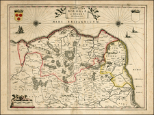
Fine large format map of France, from one of the monumental atlases of the latter 17th Century.
Hubert Jaillot created the first grand format large scale atlas of Europe. Utilitizing cartographic details which he credited to Nicolas Sanson, Jaillot's atlas was by far the largest and most commercially successful work of its kind published at the end of the 17th Century, and inspired Pierre Mortier, John Senex and Hermann Moll, to create atlases of similar size over the course of the next 50 years, although none achieved the same level of success as Jaillot.
Alexis-Hubert Jaillot (ca. 1632-1712) was one of the most important French cartographers of the seventeenth century. Jaillot traveled to Paris with his brother, Simon, in 1657, hoping to take advantage of Louis XIV's call to the artists and scientists of France to settle and work in Paris. Originally a sculptor, he married the daughter of Nicholas Berey, Jeanne Berey, in 1664, and went into partnership with Nicholas Sanson's sons. Beginning in 1669, he re-engraved and often enlarged many of Sanson's maps, filling in the gap left by the destruction of the Blaeu's printing establishment in 1672.
![(France, Belgium, and Holland) Tabula Moderna Francie [Modern Map of France]](https://storage.googleapis.com/raremaps/img/small/101885.jpg)
![[La Rochelle] Rochella Munitissimum Galliae Opp.](https://storage.googleapis.com/raremaps/img/small/77250.jpg)