
This item has been sold, but you can enter your email address to be notified if another example becomes available.


|
||

|

|
|

|
Stock# 46493
Description
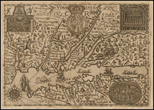
First edition of Carey's map of Virginia, one of the earliest obtainable maps of Virginia published in the U.S.
Wheat & Brun note:
This is a topographical map showing much detail. Many towns and court houses are indicated; county names are given but no boundaries, and a number of roads are shown. The western boundary follows the west fork instead of the east fork of the Gr: Sandy R. [i.e., the Big Sandy River] to the Cumberland Divide. The northwest corner of North Carolina is shown on the Blue Ridge Divide instead of on Stone Mountain.
John Reid would later copy this map for his American Atlas, with minor changes.
Reference
Swem 354; Coolie Verner 28; Wheat & Brun 568.

![[ Fredericksburg, Virginia ] Le Port de Fredericsbourg dans l'Amerique](https://storage.googleapis.com/raremaps/img/small/86570.jpg)
![(Powhatan Burial Practices) Regulorum Sepulcra XXII [Tombs of the Rulers]](https://storage.googleapis.com/raremaps/img/small/99647.jpg)