


|
||

|

|
|

|
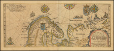
One of the Earliest Maps of Russia published in England.
Old color example of Richard Blome's scarce map of Russia, the earliest folio sized map of the region to be engraved in England.
The map reaches to the Caspian Sea and Ukraine in the South.
While Speed's atlas was published prior to Blome, Speed's map plates were engraved and printed in Amsterdam. The map demonstrates the naïve engraving style characteristic of 17th Century English engravers, and features an heraldic cartouche and dediciation to the Right Worshipfull Governer Consulls and Court of Assistance of the Company of Moscovia Merchants.
Blome first began engraving maps for his Geographical Description Of The Four Parts Of The World, in 1667, which contained 24 maps (plus one duplicate), engraved by Francis Lamb, Thomas Burnford and Wenceslas Hollar. Blome's principal handicap in the production of the atlas was the lack of a domestic mapmaking environment comparable with that in Europe. Also, to finance his work, he undertook subscribers, in exchange for a promise to add their coat of arms to certain maps. In later editions, if the renewal fee was not paid, Blome added a different subscribers coat of arms, leading to multiple images on various editions of the same map.
![(Russian Adventurism in China) Карта Средней Азии Составлена К. Веберомъ... 1871. [Map of Central Asia Compiled by K. Weber... 1871.]](https://storage.googleapis.com/raremaps/img/small/58597.jpg)
![[ Russia ] A Mapp of the Estates of the The Great Duke of Russia Blanch, or Moscovia . . . 1669](https://storage.googleapis.com/raremaps/img/small/85537.jpg)