


|
||

|

|
|

|
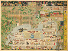
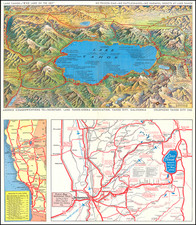
Decorative promotional map of Lake Tahoe, drawn by Gerald Eddy, to illustrate an early tourist brochure for the Lake Tahoe Sierra Association.
The brochure features a color pictorial bird's eye view map by Gerald Eddy, showing Lake Tahoe and surrounding mountains and resorts and a map showing a larger area including "Fifty-One Historical Spots, Sutter's Fort, State Capitol, Crocker Art Gallery, etc."
The map extends to Reno, Virgina City, Pyramid Peak and Donner Lake.
Gerald Eddy would go on to produce several other early pictorial maps of the Lake Tahoe region.
Gerald Allen Eddy moved from Michigan to Southern California in 1902.
From the 1920s, he worked in the Los Angeles area as an artist and commercial cartographer.
Eddy produced a number of pictorial and other maps of the western part of the United States. His earliest work was "Pushing Hun out of Franc eand Belgium" (1918). He produced several other war related maps during WWII, but is best known for his tourist and pictorial maps of California, Nevada and Arizona, including his "The Heart of Arizona" in 1926 and Boulder Dam map of 1931 and his iconic series of maps of Lake Tahoe.