


|
||

|

|
|

|
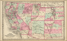
Pike's Peak Gold Rush Map Locating Camp Walbach
Fine early map showing the Gold and Silver Regions in Colorado, at the outset of the Pike's Peak Gold Gold Rush.
The map provides a fine overview of the Western part of Colorado, from Bent's Fort, Fort Laramie and St. Vrain's Fort to Salt Lake City, with a wide swath of area referred to as "Gold and Silver Region."
Fremont's routes in 1843 and 1844 are shown, as is Stansbury's route in 1849 and Gunnison's Route in 1853. Other major landmarks include Fort Bridger, Camp Walbach, Uintah Fort, Fort Definance, Fort Marcy, Fort Union, Fort Massachusetts, etc.
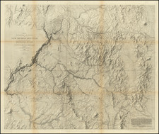
Campe Walbach--Overland Trail
Camp Walbach, 25 miles Northwest of Cheyenne, Wyoming, and directly west of the crossing at the head of Lodge Pole Creek, was established to guard and protect the emigrants through Cheyenne Pass, a dangerous spot on the new Overland Trail.
Established as a military post September 20, 1858, the camp was utilized for less than a year and was abandoned on April 19, 1859. Named for General J. B. Walbach, who said at the time the camp was constructed: "This was the route which should have been adopted when the road was changed from the Sweetwater and South Pass in 1862," meaning changing from the Oregon Trail to the Overland Route.
After going through Cheyenne Pass, the emigrants were soon on the Laramie Plains, where this trail connected and became a part of the Overland Stage Route from the south. This road was never a mail route, but strictly and exclusively one for emigrants, who were driven from the Oregon Trail, unless in caravans, by the hostility of the Native Americans.
![[ Colorado ]](https://storage.googleapis.com/raremaps/img/small/99487.jpg)
![[Report and] Map of an Exploring Expedition to The Rocky Mountains in the Years 1842 and to Oregon & North California in the Years 1843-44 By Brevet Capt. J. C. Fremont of the Corps of Topographical Engineers . . .](https://storage.googleapis.com/raremaps/img/small/88488.jpg)