|
||

|

|
|

|
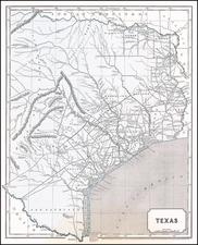
One of the earliest separate maps of Texas, published shortly after its Independence.
Shows Texas extending to the Nueces, with a note expressing hope that the boundary will be extended to the Rio Grande. The named Grants are McMullen & McGlone, Woodbury, Cameron (2), Austin & Williams, Austin, DeWitt, Austin's Colony, De Leon, Burnet, Powers, Whelin, Zavallo and Felisola. A note on Col. Milam is shown below the Red River. Also shows towns, several early 19th Century battle grounds, roads, etc. David Edward travelled to Texas in 1830 and was a keen, if pro-Mexican observer.
The book is as follows: The History of Texas; or, The Emigrant's, Farmer's, and Politician's Guide to the Character, Climate, Soil, and Productions of that Country: Geographically Arranged from Personal Observation and Experience. Cincinnati: J. A. James & Co., 1836. 8vo. xii, 336 pp. Blue cloth over boards.
Edwards, who had lived in Texas, divides his work into nine books devoted to such topics as Geography, Water, Timber Lands, Climate, Savages, The Mexicans, People of Texas and concluding with practical advice to emigrants. Pages 332-336 contain the complete text of the proposed "Constitution of the Mexican United States" and, as noted by Streeter, reprints other rare and significant early documents relating to Texas. The map contains a note stating that "Col. B.R. Milam, before entering on the duties of his second grant fell at the storming of Ft. Alamo (San Antonio de Bexar), Dec. 10, 1835."
![[ Mexican Railroads ] Carta De Comunicaciones De Los Estados Unidos Mexicanos Formada de orden de la Secretaria de Estado y del Despacho de Comunicaciones y Obras Publicas, por el Coronel Bodo von Glumer . . . Primera Hoja. 1895 - 1896. (and) Segunda Hoja 1895 - 1896](https://storage.googleapis.com/raremaps/img/small/103235.jpg)
![[Manuscript Map of Oil Development at High Island, Texas]](https://storage.googleapis.com/raremaps/img/small/66465.jpg)