


|
||

|

|
|

|
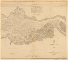
Rare separately published map of Northwestern Oregon, printed by Rand McNally & Co. for the Oregon & California Railroad Company.
The map extends from the Columbia River to Yaquina Bay and Corvallis in the South. The map shows the coastal region and mountain range between Astoria and Sweet Home. The map also shows thirty and twenty mile limit for the Oregon and California Railroad grant, and also the military road grants for Willamette Valley and Cascade Mountains, and Corvallis and Yaquina Bay.
The Oregon & California Railroad Company
The Oregon and California Railroad was formed from the Oregon Central Railroad when it was the first to operate a 20-mile stretch south of Portland in 1869. This qualified the Railroad for land grants in California, whereupon the name of the railroad soon changed to Oregon & California Rail Road Company.
In 1887, the line was completed over Siskiyou Summit and the Southern Pacific Railroad assumed control of the railroad. However, it was not officially sold to Southern Pacific until January 3, 1927.
Rarity
The map is very rare on the market. OCLC locates 2 examples (Oregon Historical Society and University of Oregon).
![[Report and] Map of an Exploring Expedition to The Rocky Mountains in the Years 1842 and to Oregon & North California in the Years 1843-44 By Brevet Capt. J. C. Fremont of the Corps of Topographical Engineers . . .](https://storage.googleapis.com/raremaps/img/small/88488.jpg)
![[Oregon Territory] Carte de l'Oregon (and) [Astoria Factory]](https://storage.googleapis.com/raremaps/img/small/77722.jpg)
![Map of Oregon, Washington and Part of Idaho [First Appearance Of Idaho Territory, including western Montana and Western Wyoming]](https://storage.googleapis.com/raremaps/img/small/94211.jpg)