|
||

|

|
|

|
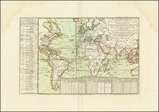
Rare Covens & Mortier edition of Carol Allard's highly influential map of the world, embellished with an additional 12 smaller hemispheric and scientific Projections.
Double Hemisphere map, surrounded by additional hemispheric projections, one of the earliest maps to abandon the baroque style of the 17th Century for a more scientific appearance. Traditional double hemisphere, plus eight other spheres, showing the world in various orientations.
Allard's innovative style of presenting multiple hemispheric projections as the embellishments around the primary double hemisphere map was copied by a number of other later mapmakers, including Schenk, Zurner, Homann and Seutter.
Carel (Carol) Allard (Allardt) (1648–1709) was an engraver and publisher based in Amsterdam. Part of a prominent family of Dutch mapmakers, publishers, and print sellers, his father was engraver and publisher Hugo Allard (1627–1684), who left his business to Carel upon his death. Carel published anything in demand, including maps, topography, ethnography, newsprints, and restrikes of old plates of artistic prints, many of which likely came from his father’s stock. In 1706, Carel gave his copperplates to his son Abraham Allard, before going bankrupt.
Covens & Mortier was one of the largest and most successful publishing firms in Dutch history and continued in business for over a century. Pierre Mortier the Elder (1661-1711) had obtained a privilege in 1690 to distribute the works of French geographers in the Netherlands. After his widow continued the business for several years, Cornelis (1699-1783) took over in 1719.
In 1721, Mortier forged a partnership with Johannes Covens (1697-1774), who had recently married Cornelis’ sister. They published under the joint name of Covens & Mortier. In 1774, upon the death of his father, Johannes Covens II (1722-1794) took over his father’s share. In 1778, the company changed its name to J. Covens & Zoon, or J. Covens & Son.
Covens II’s son, Cornelis (1764-1825), later inherited the business and brought Petrus Mortier IV back into the fold. Petrus was the great-grandson of Petrus Mortier I. From 1794, the business was called Mortier, Covens & Zoon, or Mortier, Covens, & Son.
The business specialized in publishing French geographers including Deslisle, Jaillot, Janssonius, and Sanson. They also published atlases, for example a 1725 reissue of Frederik de Wit’s Atlas Major and an atlas, with additions, from the works of Guillaume Delisle. There were also Covens & Mortier pocket atlases and town atlases. The company profited from acquiring plates from other geographers as well. For example, the purchased Pieter van der Aa’s plates in 1730. Finally, they also compiled a few maps in house. At their height, they had the largest collection of geographic prints ever assembled in Amsterdam.
![[Grotto of Tethys -- Versailles] Le Soleil qui se couche dans la mer / Le Globe de la Terre, divise en six parties.](https://storage.googleapis.com/raremaps/img/small/79606.jpg)
![[Tasman Discoveries]. Orbis Terrarum Typus De Integro In Plurimis Emendatus Auctus, Et Icunculis Illustratus](https://storage.googleapis.com/raremaps/img/small/83872.jpg)