


|
||

|

|
|

|
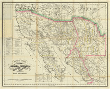
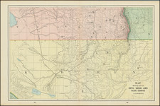
The Most Cartographically Advanced Mining Map Northern Mexico & The Borderlands of the United States of the Period
Remarkably detailed regional map, printed by Britton & Co. Lithographers, in San Francisco and was jointly published by Gensoul in San Francisco and Ch. Albessard in Paris, France.
The Gensoul map builds significantly on the 1858 Ehrenberg map of the same region, showing vastly more detail and accuracy in the region. Attractively executed, it provides an excellent image of Northwestern Mexico, Baja California and the border areas of the United States, with indication of the vast mineral resources. The map includes itineraries and symbol references in both Spanish and English.
The map's primary feature is its fine treatment of the Sonora, Chihuahua and Sinaloa, regions that had to date not been mapped in such great detail, with special emphasis on the location of the mining regions. The map credits Colonel E. de Fleury as the primary source of the map. While we have located references to the map, it would seem that with the exception of the credit provided to Fleury in the title of the Ehrenberg map of 1858, all of the significant discussions about the Fleury map are in fact descriptions of the present map published by Gensoul in 1864.
The detail along the borderlands between Paso Del Norte (now Ciudad Juarez, across from El Paso, Texas), and San Diego, California, is of great value, giving the location of the newly delineated "Frontera Nueva Segun Decreto De 4 De Julio De 1854 Despues de la Venta ou Hiso El Presidente Santa Anna De Mesilla y Arisona" (the Gadsden Purchase, in English), as well as the presumed direction of the railroad line to be run from the the El Paso area to Tucson, Colorado City (Yuma) and then into California.
The map also provides a meticulous accounting of the wagon roads and small settlements and ranches in the area, along with topographical details.
The map is also of great interest for the detail in Baja California, being quite possibly the most advanced treatment of Baja California on a printed map to date.
Warren Heckrotte comments on the map's somewhat mysterious presence:
The map presents a puzzle. It appears to be from the same plate as the original 1864 issue. But the English title, the attributions to Fleury, to the publisher Gensoul, and to the lithographer Britton & Co. are not present. The copyright imprint appears to have been erased after printing. Quite possibly it is a proof copy. I have another copy, complete, Spanish and English titles. Fleury was a Coronel and Gefe [chief] engineer in Sonora and apparently a member of the French contingent then holding power in Mexico. The map was revised in 1881 and issued in Hamilton, Leonidas. Border States of Mexico: Sonora, Sinaloa, Chihuahua, and Durango, Second Edition, San Francisco, 1881. The revised issue may also have been issued separately.
This map is a rare and bibliographically complex map, as there are several early editions with noticable differences, including an example printed in a Sepia color, a later 1881 edition of the map (so dated), an example with only an English title and the original copyright information cancelled, and at least one other variant setting of the title, with a different placement. We note the following editions:
- 1864 Heckrotte-Proof Copy: No copyright or Britton & Co. Lith imprint. No credit to Fleury or Gensoul. Second titles in French & English not present. Outline color borders.
- 1864 Present edition:
- 1864 Sepia print edition.
- 1881 Edition: Similar to present edition, but title box extends lower, French title moved to the right of the main title and the name George Holbrook Baker appears as lithographer and the imprint of Warren Holt.
The map is very rare on the market. We note only the Heckrotte copy and 1 other example offered for sale in reported auction and dealer catalog records going back more than 50 years.
![[Lake Tahoe - Sierra Nevada - Gold Country] Scenic Highways](https://storage.googleapis.com/raremaps/img/small/63009.jpg)
![Mapa et tierra q[u]e yos pedro Vial taigo transitau en St. Tafee este dia 18 de Octubre de La ao 1787](https://storage.googleapis.com/raremaps/img/small/3645.jpg)