|
||

|

|
|

|
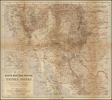
Scarce map of Texas and the West, published in Cincinnati.
In Oregon Territory, a number of early Amreican Forts are shown, along with Astoria and Oregon City.
To the south, the Gold Region is shown in California, limited only to the area north of New Helvetia (Sutters Fort area), suggesting that the map was issued shortly after the discovery of Gold in California. The map also locates the California Missions and General Kearney's Route from the Salt Lake area to Southern California. The map also locates the 1848 (Guadalupe Hidalgo Treaty) boundary between the US and Mexico.
In the Rio Grande Valley, all the major New Mexico settlements are shown.
In the Colorado area, Ft. St. Vrain, Bent's Fort, Ft. Pueblo and Fort Laramie are shown, the latter on a clearly demarcated Oregon Route.
The remnants of a Texas Republic / Stove Pipe boundary can be seen, with many settlements and the Commanche lands shown in Texas.