|
||

|

|
|

|
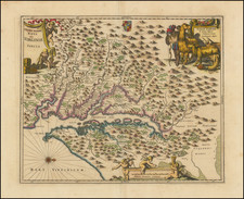
Early English Colonial Map of Virginia
Rare map of Virginia, engraved by Ralph Hall, for Wye Saltonstall's Historia Mundi.
This remarkable map of Virginia is based in part upon John Smith's map of Virginia, embellished with a lively and unique ethnographical view of Virginia, shortly after the English established a colony at Jamestown. Hall's map is the earliest map of Virginia based upon John Smith's model and is quite rare on the market.
The map was originally intended to be included in the first edition of Historia Mundi, but when it was not yet ready, the publisher included a note at the end of the errata, stating "In Page 905 for the Description of New Spaine read New Virginia, but there is no map of Virginia in regard where is a more exact Map drawing in that Country whose Platforme is not yet come over, but when it comes, every buyer of the Booke shall have it given him gratis."
The map includes views of native Americans sitting around a fire and idol, view of a charnel house, and a view of a settlement surrounded by wooden palisade, canoes, ships, sea monster, royal English coat of arms, animals such as pigs or peccaries, a jaguar, native fortification, and natives and Europeans hunting with muskets and bows.
The New Virginia referenced in the text note refers to the Jamestown settlements (as opposed to Sir Walter Raleigh's Virginia, which is described elsewhere in the text). The map is an imaginative adaptation of Smith's map of Virginia, which includes the location of Hall=poynt in the middle of the map, a fictitious placename added by the map maker. The illustrations and ethnography are drawn primarily from John White's map of Virginia.