|
||

|

|
|

|
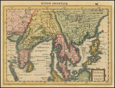
Striking map of the Northern Indian Ocean, and parts of India, Ceylon and SE Asia, centered on the mouth of the Ganges River.
The map was used to illustrate Vander Aa's Dutch edition of the voyage of Lopo Soares d' Albegeria in 1515 on behalf of the King of Portugal by the Portuguese historian Joan de Barros.
Names China, Cocinchina, Siam, Cambodia, and some other relatively modern place-names for the early 18th Century.
Pieter van der Aa (1659-1733) was a Dutch mapmaker and publisher who printed pirated editions of foreign bestsellers and illustrated books, but is best known for his voluminous output of maps and atlases. Van der Aa was born to a German stonecutter from Holstein. Interestingly, all three van der Aa sons came to be involved in the printing business. Hildebrand was a copper engraver and Boudewyn was a printer.
![[ Tibet / Nepal / Himalyas ] Carte von Tibet nach den neuesten Nachrichten entworfen 1790](https://storage.googleapis.com/raremaps/img/small/86165.jpg)
![[India] Tabula Asiae X](https://storage.googleapis.com/raremaps/img/small/89683.jpg)