|
||

|

|
|

|
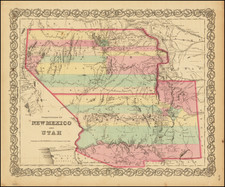
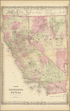
Rogers & Johnston' rare map of California, from the Atlas of the United States, perhaps the most coveted of all mid 19th Century American Atlases.
This now rare atlas derives from a Wall Map first published in 1857 as a collaboration between Rogers of New York, and Johnston, the Scottish publisher. The work was remarkably detailed and up to date, and includes some of the only separately issued maps of certain western territories, including a separate double wide New Mexico, double wide Utah, oversized Nebraska, and several other remarkable maps which were never issued separately by any American publisher.
This map of California is remarkably detailed, much more so than contemporary American atlas maps. It includes numerous annotations, towns, mountains, rivers, lakes, elevations, deserts, Indian notes, etc. Bigelow Lake is shown with a Mormon Settlement just to the east. Both Owens and a still large Mono Lake are shown. An early rail line from Benicia to Yuba City is shown. Many of the elevations are wildly inaccurate, including Mt. Shasta at 17,600 feet and San Gorgonio Pass at 2808.
Excellent detail in the Southern California Mountains. This map is without doubt the best atlas map of the period for California and also by far the rarest.
An essential map for California Collectors.