


|
||

|

|
|

|
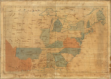
The Final State of Bradley's Postal Map of the United States -- Extensive New Revisions To Mississippi River and Southern Illinois
Northwestern Section of the 1812 edition of Abraham Bradley's Postal Map of the United States, one of the most important early maps of the United States.
As discussed in greater detail below, this section of the 1812 edition of the map is the first state of Bradley's map to include major revisions in the area around St. Louis, with significant revisions to the location of the City of St. Louis, the course of the Mississippi River, Missouri River and adjacent topographical and geographical features.
Overview of Bradley's Postal Map
Abraham Bradley's postal map is the first postal map of the United States and a landmark in both the history of cartography and American Postal history.
Abraham Bradley was a Litchfield, Connecticut, lawyer, who had an extraordinary career as a senior civil servant in the U.S. Post Office Department. Bradley joined the Postal Department in 1792, was promoted to First Assistant Postmaster General in 1800, and served until being removed from office in the Jacksonian purges of 1829.
It is hard to overstate the importance of the Postal Department in the first decades after the revolution. The founders saw effective postal service as a precondition for an informed citizenry and vibrant democracy, and Postmaster General was one of the first Cabinet positions created by Washington. At times during Bradley's tenure, the Postal Department accounted for more than 75% of the Federal bureaucracy. By his retirement, Bradley oversaw more than 8000 local offices and 110,000 miles of post roads. During these years, Bradley essentially acted as the Department's Chief Operating Officer, overseeing among other things route selection, contracting, finances and even responding to complaints about lost or stolen mail. In light of his position, Bradley was arguably the American most motivated to produce a viable postal map, and certainly the best informed.
First issued in 1796 (northeast sheet only), Bradley's postal map is among the most important maps in American history. Bradley's map is one of only 4 large format maps of the United States to have been published in America prior to 1800, two of which (maps by Abel Buell and John Norman) are unlikely to ever again appear on the market.
The map provides an exceptionally detailed look at the post offices and postal routes of America, as they existed at the end of the 18th Century, locating every post office then in operation. The map also includes the first printing of the first American postal delivery time and route schedule (which may have also been issued separately, although there are no known separately printed examples which have survived).
In 1796, when Bradley published his first Map of the United States, Exhibiting the Post-Roads, the Situations, Connections, and Distances of the Post-Offices, less than 15 years after the end of the War of Independence, most citizens of the fledgling United States still had no real conception of the magnitude of their young nation. Bradley's postal map, with its schedule chart, was a perfect combination of Bradley's skills and obsession for precision scheduling. This unique U.S. map was on public display in almost every large post office in the country, and provided citizens with an impressive visual depiction of the scope of the United States at a time when the search for a national culture and national identity was at its height, after the final and official separation from Great Britain. The inclusion of stagecoach schedules promoted, encouraged and broadened popular notions of the concept of time beyond seasonal and religious practices.
The map was advertised for sale on October 3, 1796 as follows:
The above map may be had of the author at the General Post-Office…..Prices from 3 ½ to 5 dollars each, according to the manner in which they are finished. The progress (or arrivals and departures) of the Mail on the Main Line may be had separate for 37 ½ cents
For many colonial residents, the Bradley's map was the iconic symbol of a unified United States. Citizens began to consider (and later demand adherence to) weekly and daily notations of time, as measured by the institution of regularly-scheduled mail service.
The map's true value is its exceptionally detailed depiction of the post offices and post routes of the young United States at the end of the 18th century. Buehler and Caldwell note:
What makes the map extraordinary is its depiction of the American postal system in a single coherent image. It shows every one of the roughly 450 existing post offices and every postal route, with distinctive symbols differentiating "post roads," "post roads established by contract," and "post and stage roads." Each route is marked to indicate the mileage between post offices. The varying density of the network displayed on the map serves as a profile of national expansion and development. ("Mapping a Networked Nation," p. 10)
A fascinating historical footnote for Bradley's map was its use by Louis Philippe, Duc d'Orléans, future King of France (1830-1848), during his travels in America. Louis Philippe spent more than three years in American exile, from 1796 to 1800. At the beginning of his exile in 1796, he and his two brothers visited an aging George Washington at Mount Vernon, where they revealed their desire to explore the mysterious interior of America. Washington presented them with a copy of Bradley's map and outlined a route for the brothers in read. The map became a favorite keepsake for Louis Philippe, who years later, as King of France, would proudly produce the map for visitors and share the story of how Washington had relined the map in his own hand for a young Louis Philippe and his brothers.
The first edition of the map is known in 4 states, which can be identified as follows:
- State 1: Northeast Sheet only
- State 2: 4 sheets, including the Time Table
- State 3: Georgia named, but appearing on 2 lines (GEOR/GIA). Copyright date of September 26, 1796, appears in top left corner.
- State 4: Note in Georgia: "All West of this line is claimed both by the United States and by Georgia). A symbol for discountinued post roads is shown.
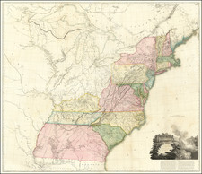
The Second Bradley Postal Map
By 1804, the US Postal system had grown to over 1400 post offices. With the addition of the Louisiana Purchase in 1803, it became time to signfiicantly revise and expand Bradley's map. On August 29, 1803, Bradley wrote President Thomas Jefferson, noting that:
The great alterations which have taken place in the U.S. since my map was first published have rendered it of little use & I have for sometime suspended the sale.
An enlarged second edition was published in June 1804 (with revised editions issued in 1805, 1809 and 1812). The map was over 50% larger than the prior map, with significant coverage of the area west of the Mississippi River in the future states of Louisiana, Arkansas, Missouri, Iowa, Wisconsin and Minnesota.
As with the first edition, Bradley set out to include every postal road in the United States, with mileage also depicted.
Revisions To The Northwestern Sheet in 1812
In 1812, Bradley issued the last of the revised editions the map. For the Northwestern Sheet, significant geographical revisions were made along the Mississippi River and its tributaries, likely in large part due to the increased activitity along this section of the Mississippi River following the Louisiana Purchase. In 1810, Zebulon Pke produced his Map of the Mississippi River from its Source to the Mouth of the Missouri: . . .
The Northwestern Sheet extends from 38 degrees north 46 degrees north latitude and to 19 degrees west, including the Great Lakes, Ohio, Indiana, Illinois, Michigan, Missouri, Iowa and Wisconsin.
The most noteworthy changes to the map are centered on the St. Louis area. These include:
- The relocation of St. Louis by approximately 5 miles (which had previously been due east of St. Charles).
- A significant revision of the road between St. Louis & St. Charles and the road between St. Louis and Cahokia.
- A dramatic revision in the courses of the Missisisippi River, the lower Missouri River and the Lower Illinois River immediately north of St. Louis.
- To the east, the earliest evidence of the township surveys undertaken in southern Illinois are now shown, with significant revisions to the topographical features on the east side of the Missisisippi River.
- A Curious partial erasure of the R. Beuf, R. Oahahala, R. Jaurlione and Fabian R. west of the Mississippi and north of the Illinois confluence, as well as the unnamed river betrween the two rivers, as a result of the redefinition of the course of the Mississippi. without any apparent effort to reconnect these rivers to the Mississippi.
- Revisions to the course of the Mississippi south of St. Louis and North of Chartres Fort.
- Adjustment of the Kaskaskia River several miles to the east of Prairie du Rocheres.
- Addition of Herculeum and Harrisonville on either side of the Missisissippi River north of Prairie du Rocheres.
- Revisions of the location of the post road on the east side of the Mississippi between Genevieve and Prairie due Rochere, with addition of at least 1 town and recolocation of St. Philip.
- Removal of the Reserve square at the confluence of the Mississippi and the Illinois Rivers.
Other changes of note include:
- Partial deletion of the name of the R. Moin (De Moines River).
- Significant revisions to the course of the Ohio River, immediately east of its confluence with the Wabash River.
- Significant revisions to the course of the Wabash River between the Little Wabash and the Ohio River.
This would be the final version of the second edition of the map, with a third state of the map issued in 1825.
Rarity
There are no recorded examples of any state of the Bradley map in any institutional collection west of the Mississippi River (although the donation of the Rumsey Collection to Stanford will ultimately include an 1809 and 1812 state of the map in the Stanford Collection).
Buehler & Caldwell locate 4 complete examples of the 1812 map, as well as partial copies at the American Geographical Society, Library of Congress and University of Michigan.
The present example was deacessioned by the Library of Congress to the Old Print Shop prior to 1980.
The full text of Buehler & Caldwell's article can be found here: http://bostonraremaps.com/wp-content/uploads/2015/09/portolan-spring10-bradley-reprint.pdf
Abraham Bradley was born in Litchfield, Connecticut. He is an important figure not only in early American cartography, but in early American history as well. Initially, Bradley trained as a lawyer and moved to the Wyoming Valley of Pennsylvania to practice. There he met Judge Thomas Pickering, who took Bradley with him to Philadelphia when he was appointed Postmaster General by George Washington in 1791.
As Pickering's clerk, Bradley created postal maps which showed the budding system of post offices and routes. A self-taught mapmaker, Bradley quickly gained considerable skill and became well-known for this carefully drawn maps. His most famous map is the postal route map of 1796, which shows the young United States and includes an innovative table that calculated the time it would take a letter to travel around the country.
In 1799, Bradley was appointed Assistant Postmaster General, a position he would hold until 1829. As part of his duties, Bradley supervised the moving of the General Post Office Department from Philadelphia to Washington DC. In 1804, with the help of British mapmaker Aaron Arrowsmith, Bradley updated his postal map, which featured in practically every post office in the states and territories. Bradley would continue to create route maps, and to update his most famous map, throughout his career, including in 1810 and 1825.
During the burning of Washington DC in the War of 1812, Bradley housed the records and archives of the General Post Office Department in his Maryland farmhouse. His service with the Post Office came to an abrupt end, however, with the election of Andrew Jackson. Although he had served under five Postmasters General, Jackson dismissed Bradley for partisan reasons. Bradley then served as secretary to the Franklin Insurance Company. He died at his farmhouse in 1838, leaving behind eight children. He is remembered for his careful custodianship of the nascent Post Office, and for creating maps that made Americans feel connected to their fellow citizens.
![[Grateful Dead Tour Poster] The Original Grateful Dead Wall Map & Tour Guide Volume 1 / The Golden Road To Unlimited Devotion](https://storage.googleapis.com/raremaps/img/small/85630.jpg)
