


|
||

|

|
|

|
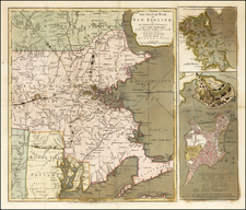
Large Promotional Map of Lake Champlain
A rare map of Lake Champlain issued by Seneca Ray Stoddard of Glens Falls, New York, in 1901.
Issued in an unusual elongated format, this map covers the entirety of Lake Champlain, and the adjacent parts of Vermont and New York, from Missisquoi Bay and Rouse's Point to Fort Ticonderoga.
The author detail rail lines, basic topography, islands throughout the lake, and roadways. There are insets detailing the lower portions o the Lake from Whitehall to Fort Ticonderoga, Lake George, the Richelieu River, the route of the Steamer Coquette, distances form Plattsburgh, and distances from Caldwell. Cartographically this map is mostly likely derived form the work of the United States Coast Survey.
Stoddard first issued this map in 1892, and as such it is one of the earliest tourist maps to focus exclusively on Lake Champlain. He sold this map by mail order for 50 cents, postpaid. Stoddard issued numerous revised editions to at least 1907.
![(Colonial New England Ironworks) [Early 19th-century manuscript copy of 1674 New England land transaction involving John Gifford; mention of early ironworks in Massachusetts]](https://storage.googleapis.com/raremaps/img/small/93113.jpg)
![[ New England / Northeast / Canada ] Tierra Nueva](https://storage.googleapis.com/raremaps/img/small/86737.jpg)
