This item has been sold, but you can enter your email address to be notified if another example becomes available.


|
||

|

|
|

|
Stock# 45865jc
Description
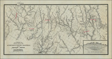
Rare map of the San Diego area by H.T. Christianson & Co., illustrating the city in connection with a proposed location of military installations in San Diego.
The map shows False (Mission) Bay, the townplan and wharf for Roseville in San Diego Bay and the locations of Old Town, Middle Town, New Town and Horton's Addition.
The location of the Post Office in Downtown San Diego is shown, as is a Steamship Wharf. Ballast Point and a fort are shown on Point Loma, along with the lighthouse.
The Line of the San Diego, California & Eastern Railroad is shown, along with a depot near the wharf. The San Diego Flume LIne and the location of the Mission on the San Diego River are also noted.
![[Fruit Crate Label Advertising Map] Star of California Brand](https://storage.googleapis.com/raremaps/img/small/41396.jpg)