|
||

|

|
|

|
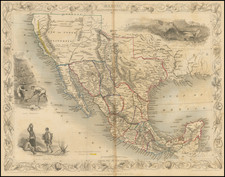
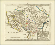
First State of Jacob De Cordova's 1849 Map of Texas, the first official map of the State of Texas and the single most influential map of Texas immediately following Statehood.
Published in Houston and signed by De Cordova himself, the first state of De Cordova's map is a Texas cartographic landmark.
This is the first issue of the first official map of Texas as a state. It is produced on a far larger scale than any previous map of the state of Texas, and the only edition of his map to include the short-lived Santa Fe County, which comprised much of New Mexico. The map shows Cross Timbers, counties, colonies, roads, German settlements, land districts, trading posts, and exploration routes. Includes "Reference to Land Districts," official State of Texas seals, legend, and notes.
The map includes a certification by Sam Houston, Thomas Jefferson Rusk, David S. Kaufman and Timothy Pilsbury states
We, the undersigned, Senators and Representatives from the State of Texas, do hereby certify that we have carefully examined De Cordova's map of the State of Texas, compiled by R. Creuzbaur from the records of the General Land Office of Texas and have no hesitation in saying that no map could surpass this in accuracy and fidelity. It has delineated upon it every county in the State, its towns, rivers, and streams and we cordially recommend it to every person who desires correct geographical information of our state. To persons desiring to visit Texas, it will be invaluable.
Additional certifications are provided by:
- John C. Mays
- George T. Wood (Governor of Texas)
- W.D. Miller (Secretary of State)
- Thomas William Ward (Commissioner of the General Land Office)
- George W. Smyth (Commissioner of the General Land Office)
Jacob De Cordova was an early Texas land promoter and early developer. De Cordova and Robert Creuzbaur, an employee of the newly created General Land Office, compiled this map using latest surveys and drawing it on a scale far larger than any prior map of the State. First issued in 1849, it was one of the first major cartographic productions after Texas annexation into the United States to be based upon the records of the General Land Office. De Cordova was one of the earliest Jewish settlers in Texas. During the War for Texas Independence, he supplied goods from New Orleans, before settling in Galveston in 1837. He quickly took to his adopted homeland, adding several Indian dialects to the 5 languages which he spoke prior to his arrival.
After serving a term in the Texas House of Representatives, De Cordova settled in Austin, where he and his brother published the Texas Herald. Anticipating a land boom in Texas following the Mexican War, he began speculating in land and for the next 30 years, he actively promoted immigration to Texas, including promotional tours of the United States and Europe. As part of this campaign, he produced his first map of Texas in 1849. Sam Houston persuaded Congress to purchase 500 copies of the 1849 edition, arguing with Jefferson Davis in support of the quality of the map and character of De Cordova during the appropriations process on the floor of the Senate.
Jacob De Cordova, a native of Jamaica, was one of the earliest Jewish settlers in Texas. He supplied goods for the Texas Revolution from New Orleans and settled in Galveston in 1837. He was fluent in English, German, French, Spanish, Hebrew, and several Indian languages. He became one of the leading land merchants in Texas, and worked for thirty years promoting immigration into the state.
In 1847, De Cordova was elected to the Texas House of Representatives, but lost his bid for reelection in 1849. Working as a land agent, he, along with George B. Erath, laid out the town of Waco. He was instrumental in promoting immigration to Texas through speeches, professing her wonders throughout the United States and as far away as England. He also published a number of pamphlets and guidebooks including The Texas Immigrant and Traveller's Guide Book (1856) and Texas, Her Resources and Her Public Men (1858). De Cordova died in 1868.
There are a number of editions of this map. From 1849 to 1854 which De Cordova published the map himself, updating it between each edition. In 1856, he assigned the rights to J.H. Colton, who published the subsequent editions up to 1872.
The present example is in remarkably good condition, perhaps the best example to come to market in the past several decades, with a fresh clean example of Jacob De Cordova's original pen & ink signature below the title, which is only present on the true first state of the map, all others being printed in facsimile.