|
||

|

|
|

|
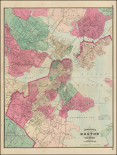
Fine Plan of the Old Fort Hill Area in Downtown Boston
Fascinating large format map of part of downtown Boston, published for the Common Council.
Detailed planning map showing part of downtown Boston, near the modern-day New England Aquarium, Harbor Towers, Norman B. Leventhal Park, and the Boston Harbor Sailing Club.
This map shows the initial land ownership and new street layout including High Street, Purchase Street, Milk Street, and Oliver Street.
Published in 1866, it shows the landowners at that time and the elevations and street layouts with new layouts and elevations superimposed over the old. This map shows the cutting of Fort Hill by up to fifty feet and has the neighborhood centering around a proposed manufacture exchange.
New roads are highlighted in a light orange-tan color, and many of these still exist. However, the majority of the changes shown on this map are now nearly gone and are barely recognizable. Not all the place names are gone, though; there is still a Fort Hill Square at Purchase Street and Oliver Street.
These proposed changes were laid out by the Committee on Laying out and Widening Streets. Three committee members are listed, including Thomas Gaffield. Gaffield (1825-1900) was a prominent glass manufacturer. He was a partner in the firm Tuttle, Gaffield and Company from 1847 to 1869; in 1861 he helped to set up the Boston Crystal Glass Works. He shared his expertise in glass in lectures to Chemistry students at the Massachusetts Institute of Technology Society of Arts. In 1896, he became a member of the MIT Corporation.