
This item has been sold, but you can enter your email address to be notified if another example becomes available.


|
||

|

|
|

|
Stock# 45777
Description
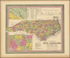
The First Map of The State of North Carolina Printed in England
Rare example of John Stockdale's map of North Carolina, from the London edition of Morse's Geography.
Mapforum's Checklist of the Printed Maps of North Carolina shows this to be the first English language map of North Carolina published following the conclusion of the American Revolution and one of only a few maps to show the state of North Carolina published prior to 1800.
The map is divided by counties and locates towns, roads, rivers, mountains, court houses, etc.
An essential map for North Carolina collectors.
![[Pamlico Sound] Coast Chart No. 145. Cape Hatteras to Ocracoke Inlet. North Carolina](https://storage.googleapis.com/raremaps/img/small/90723.jpg)
![(Southeast United States) Carte de la partie sud, des Etats Unis de L' amerique septentrionale [Map of the southern part of the United States of North America]](https://storage.googleapis.com/raremaps/img/small/98738.jpg)
![[French Colonization in Florida and the Southeast] La Floride Francoise Dressee sur La Relation des Voiages que Ribaut, Laudonier, et Gourgues y ont faits in 1562, 1564 et 1567 . . .](https://storage.googleapis.com/raremaps/img/small/91072.jpg)

