|
||

|

|
|

|
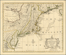
Scarce map of Washington and the Territory of Columbia, showing the extent of the entire Territory, along with an early depiction of the City of Washington, along with views of the Capitol at Richmond and Washington D.C.
Lizars' map is of special note for its depiction of the Territory of Columbia as a whole, not just the City of Washington proper. The map is apparently derived from Andrew Ellicott's Territory of Columbia, published by Thackara & Vallance in 1794. Referred to as The 10 Mile Square, the area was surveyed by Ellicott, who subsequently drew 2 manuscript plans at the request of Thomas Jefferson in 1793. The Territory consisted fo 64 square miles ceded by Maryland in 1788 and 36 square miles ceded by Virginia in 1789. While several other topographical manuscript maps were drawn shortly thereafter, the entirety of the Territory of Columbia was largely ignored in printed maps following the Thackera & Vallance map of 1794, making this work by Lizars one of the earliest depictions of the entire Territory of Columbia and one of the very few maps to refer to the region as a Territory (as opposed to a District).
Lizars map appeared in D. B. Warden's A Statistical, Political and Historical Account of the United States. The present map is from the 1819 edition. Interestingly, the 1815 edition of Warden's work includes a smaller map engraved by Pierre Tardieu, entitled simply Territory of Columbia.
The Lizars were a Scottish family of engravers and printers who produced many views and maps. Daniel Lizars Sr. (1754-1812) was the son of a shoemaker, but he apprenticed with Andrew Bell, a printer and engraver. Lizars set up his own printworks near St. Giles Cathedral and took on his own apprentices, including George Bartholomew, whose son John would go on to found the important mapmaking firm later know as John Bartholomew & Son Ltd.
Daniel Sr. had three sons: Daniel Jr., John, and William Home. He also had a daughter, Jane Home. Daniel Jr. (1793-1875), the youngest of the boys, apprenticed in his father’s shop alongside George Bartholomew. When his father died in 1812, Daniel Jr. took over much of the business, expanding it and specializing in maps. The company went bankrupt in 1832, however, and Daniel emigrated to Canada.
John Lizars (1792-1860), the middle son, studied medicine and became Professor of Surgery at the Royal College of Surgeons of Edinburgh, as well as senior surgeon at the Royal Infirmary of Edinburgh.
William Home Lizars (1788-1859), the eldest, also apprenticed in his father’s shop. After learning engraving, William entered the Trustees’ Academy to learn under John Graham. He was a skilled painter and artist. When his father died, and after his Daniel Jr. left, he carried on printing and invented a method of etching that looks like wood engraving.

![[Right sheet only of: A New Chart of America Florida to New York with the Principal Harbours on a Large Scale, Drawn from the latest Authorities, by Robt Blachford. 1807.]](https://storage.googleapis.com/raremaps/img/small/55819.jpg)
![A New Map of Virginia [Chesapeake]](https://storage.googleapis.com/raremaps/img/small/43053.jpg)