


|
||

|

|
|

|
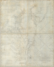
The Siege of Savannah, October 9, 1779.
Nice example of William Faden's plan of the Siege of Savannah, re-issued by Stedman in 1794.
This Revolutionary War battle plan depicts the failed American and French attack on the British held city of Savannah. Shown are the battle lines, camps, gun emplacements and topography around the city. A numbered and lettered key identifies the various positions and commanders of the various forces. The reference key includes 14 notes and 9 epaulments.
This map was first issued in 1784 by William Faden. Faden's plates were acquired and reprinted by Charles Stedman 1794 for his work, The History of the Origin, Progress, and Termination of the American War.
Neither the French nor the Americans created any maps of this battle, making the Faden plan the only obtainable contemporary map.
William Faden (1749-1836) was the most prominent London mapmaker and publisher of the late-eighteenth and early-nineteenth centuries. His father, William Mackfaden, was a printer who dropped the first part of his last name due to the Jacobite rising of 1745.
Apprenticed to an engraver in the Clothworkers' Company, he was made free of the Company in August of 1771. He entered into a partnership with the family of Thomas Jeffreys, a prolific and well-respected mapmaker who had recently died in 1771. This partnership lasted until 1776.
Also in 1776, Faden joined the Society of Civil Engineers, which later changed its name to the Smeatonian Society of Civil Engineers. The Smeatonians operated as an elite, yet practical, dining club and his membership led Faden to several engineering publications, including canal plans and plans of other new engineering projects.
Faden's star rose during the American Revolution, when he produced popular maps and atlases focused on the American colonies and the battles that raged within them. In 1783, just as the war ended, Faden inherited his father's estate, allowing him to fully control his business and expand it; in the same year he gained the title "Geographer in Ordinary to his Majesty."
Faden also commanded a large stock of British county maps, which made him attractive as a partner to the Ordnance Survey; he published the first Ordnance map in 1801, a map of Kent. The Admiralty also admired his work and acquired some of his plates which were re-issued as official naval charts.
Faden was renowned for his ingenuity as well as his business acumen. In 1796 he was awarded a gold medal by the Society of Arts. With his brother-in-law, the astronomer and painter John Russell, he created the first extant lunar globe.
After retiring in 1823 the lucrative business passed to James Wyld, a former apprentice. He died in Shepperton in 1826, leaving a large estate.
![[French & Indian War] Carte Des Possessions Francoises et Angloises dans le Canada et Partie de la Louisiane . . . 1756](https://storage.googleapis.com/raremaps/img/small/94026.jpg)
![Carte De La Louisiane Et Du Cours Du Mississipi . . . Juin 1718 [1st State!]](https://storage.googleapis.com/raremaps/img/small/59797.jpg)

![[French Colonization in Florida and the Southeast] La Floride Francoise Dressee sur La Relation des Voiages que Ribaut, Laudonier, et Gourgues y ont faits in 1562, 1564 et 1567 . . .](https://storage.googleapis.com/raremaps/img/small/91072.jpg)