|
||

|

|
|

|
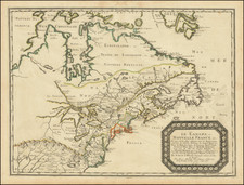
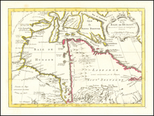
Albert Gallatin's Map and Pamphlet Describing The Webster-Ashburton Treaty of August 9, 1842.
A rare separately issued map depicting the resolution to the Maine-Canada boundary dispute, as ratified by the Webster-Ashburton Treaty of 1842, a variant of the M.S. Harrison edition of the treaty map.
This fascinating map depicts the Canada-U.S. borderland from Lake Champlain to the Bay of Fundy, and shows the various boundary claims relating to the Maine-Canada boundary dispute, as well as the final agreement, pursuant to the Webster-Ashburton Treaty of August 9, 1842.
The boundary dispute between the American state of the Maine and the British colonial provinces of New Brunswick and Lower Canada (Quebec) was one of the longest running and most acrimonious disagreements between the two nations. The origin of the dispute was found in the wording of the Treaty of Paris (1783), which concluded the American Revolutionary War and established the boundaries between the newly independent United States and what remained of British North America. The negotiators of the Treaty relied on outdated cartography, notably John Mitchell's A Map of the British and French Dominions in North America (1755), and so had a flawed understanding of the geography of the projected boundary, especially where it was to run through the interior.
The Treaty ordained that the northern section of the boundary between Maine and British territory was to run from where Quebec's boundary ended at the 45th parrellel "along the height of land" to the St. John River. While the Maine-New Brunswick boundary had been resolved from Passamaquoddy Bay up northwards to near where the Aroostook River enters the St. John River, in 1797, the boundary beyond that further to the north remained in dispute. The British claimed that the "height of land" ran along the crest of the Appalachians, so claiming a large chunk of what Maine considered to be its territory. The Americans countered that the boundary should run along the height of land dividing the watersheds of the St. Lawrence River and the Gulf of Maine, so passing the border dangerously near the St. Lawrence River, Canada's lifeline. The American claim, if implemented, would also make it difficult for the British to build an all-season road between Quebec City and the St. John Valley, as at least half of the Upper St. John region had to be secured to provide a viable route.
Unable to resolve the issue themselves, in 1831, the Americans and the British submitted their dueling claims to King Willem I of the Netherlands for non-binding arbitration. Willem duly proposed a compromise, which the British rejected outright, as it heavily favored the Americans. The situation remained tense, with officials and lumberjacks from each side almost coming into armed conflict in 1838 and 1839, in what was exaggeratively known as the 'Aroostook War'.
The governments in both Washington and London were alarmed by the Aroostook incidents and mutually wanted to resolve the boundary dispute, once and for all, so as to avoid a diplomatic catastrophe sparked by hot-headed local residents. In 1842, U.S. Secretary of State Daniel Webster met with the British Minister to the U.S., Alexander Baring, 1st Baron Ashburton, to resolve the matter. Ashburton was under pressure to ensure that the British were granted enough of the Upper St. John so as to build the Quebec-New Brunswick road, while Webster had an embarrasing problem to resolve. The U.S. Army had recently constructed a massive brick fortress on the Richelieu River, Fort Montgomery, supposedly just south of the U.S.-Quebec line (the 45th parallel). However, recent surveys had shown that the 45th parallel and the international boundary actually ran to the south of the fort. Webster was determined to rescue what became known as "Fort Blunder", by having the U.S.-Quebec boundary moved north a touch, and in return he was prepared to concede more territory in Maine to the British, enough for them to comfortably build their road. Fortunately, in this Treaty both sides received what they really needed and both sides saved face.
In the immediate wake of the Treaty, 3 different London publishers came out with versions of the map depicting the boundary resolution, each with the same title. The most common of these was by John Wyld, issued with a pamphlet, George Featherstonhaugh's Observations upon the Treaty of Washington (1843), while another version was published by Her Majesty's Printing Office with the British government's official printing of the text of the treaty.
Present here is the American edition by Albert Gallatin, published by Endicott.
A rare and well-preserved artifact illustating a seminal event of the history of New Brunswick and Maine.
![[ Karte des Nordens von America, Zur Beurtheilung der Wahrscheinlichkeit einer nord=westlichen Durchfhart, gezeichnet von G. Forster, 1791.]](https://storage.googleapis.com/raremaps/img/small/41816dm.jpg)