|
||

|

|
|

|
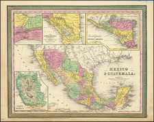
The Parke-Kern map of New Mexico Territory, the most important map of the newly formed Territory of New Mexico.
Lt. John G. Parke's map of the Territory of New Mexico is a landmark work in the history of the region. First published in 1852, the map covers the region from Pike's Peak to Cooke's wagon road in Sonora. Prepared in 1851 by Richard Kern, the map replaced Lt. J. W. Abert's as the primary source of geographical information on New Mexico..
Parke initially sent his manuscript map to the War Department, where it was printed and distributed to officers headed to the region and to others who specifically requested a copy of the map, but it was never bound into a report. The intention was to use the map as a base map for observations by field officers who were then sent to the region. As noted by Wheat, Park :
Parke's published map is a remarkable production, both because it is a composite of the maps hitherto described, and because of the wealth of additional information contained on it. It would be of little assistance to attempt to describe this latter aspect of this map; it must be gained from a view of the map itself.... North of the route proposed by Simpson at such length the canyons of the Colorado are not shown, but the Moqui (Hopi) country, the Cerro Abajo and the Cerro la Sal, and the Green and the Grand rivers appear.... In the far northwest, in Utah Territory below the Wasatch range, and stretching east from Vegas (Las Vegas, Nevada), is "The Spanish Trail leading from the Pueblo de los Angeles California to Abiquiu New Mexico".... The names along the upper Grand River, and in the valley at the head of the Rio Grande del Norte, are remarkable in that they here appear so early, and though this whole country on the north and west is labeled "Unexplored," this map must have been an eye-opener to Beale and Frémont, who passed through the Green and Grand area on their separate ways to California in 1853.
Because the map was never published in an official report and was only issued separately, it is now rare on the market, this being only the second example we have handled in over 20 years.

![[DeWitt Clinton Copy] An Account of Expeditions to the Sources of the Mississippi, and through the Western Parts of Louisiana, to the Sources of the Arkansaw, Kans, La Platte, and Pierre Jaun, Rivers During the years 1805, 1806 and 1807. And a Tour through the Interior Parts of New Spain. in the year 1807.](https://storage.googleapis.com/raremaps/img/small/81745.jpg)