|
||

|

|
|

|
Decorative Map of Jerusalem published in Haifa.
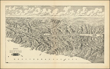
Second state of Hermann Bollmann's map of Jerusalem, first printed in 1969.
This is a bird's eye view map of Jerusalem as it was between 1967 and 1969.
Hermann Bollmann was a German cartographer who was commissioned by Wim van Leer to make a three dimensional map of Jerusalem. The draftsmanship of this map is extremely precise and is based on ground and aerial photographs.
The map depicts every building, with every window and balcony. Prominent are, of course, the Old City with its walls and the Dome of the Rock, the red roofed buildings of the older neighborhoods, the stadium at the Hebrew University campus, and the newly erected Knesset (Parliament) building.
The border of the map includes the name Jerusalem in 16 languages.
![[Beirut, Lebanon] The Port of Beirout in Syria](https://storage.googleapis.com/raremaps/img/small/76131.jpg)