


|
||

|

|
|

|
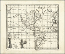
Rare Western Hemisphere map showing California as an island, published by Melchior Tavernier.
Tavernier's map provides a fine blend of contemporary cartographic information with unique details in the concentric circles outside of the geographical hemisphere.
In the outermost circle, Tavernier names the 32 compass point directions in French. In the center circle, are the names of the 12 Classical Winds described by Timothenes of Rhodes (circa 282 BC) in both Latin and the original Greek spellings (see below). In the innermost circle, the 8 Winds of the Mediterranean (the modern compass points) are named (Tramontane, Greco (Grecale), Levante, Sirocco, Austral (Ostro or Mezzogiorno), Sebaca (Libeccio or Garbino), Ponent (Ponente) and Maestral (Mistral or Maestro)).
Cartographically, the map is a marvelous blend of information and conjecture. Tavernier treats the massive northwestern landmass to the north of California as conjecture, employing a lighter coastal outline to signify that the lands depicted are not known with certainty. California is shown as a curiously shaped island, not consistent with either the Briggs or Sanson models. A single Great Lake is depicted.
In the Arctic Regins, a notation describes Thomas Button's search for a Northwest Passage. In South America, there is a small Lake Parime in Guiana, and both the Amazon and Rio de la Plata flow from the large interior Lago de los Xarayes.
The 12 Classical Winds of Timothenes of Rhodes
In the Geographia of the Greek-Roman physician Agathemerus, eight principal winds are named. However, Agathemerus notes that nearly five hundred years earlier, the navigator Timosthenes of Rhodes had developed a system of 12 winds by adding four winds to the eight.
Timosthenes's list (according to Agathemerus) was Aparctias (N), Boreas (not Meses, NNE), Caecias (NE), Apeliotes (E), Eurus (SE), "Phoenicias is also called Euronotos" (SSE), Notos (S), "Leuconotos alias Libonotos" (first mention, SSW), Lips (SW), Zephyrus (W), Argestes (NW) and "Thrascias alias Circius" (NNW).
In many ways, Timosthenes marks a significant step in the evolution of the compass rose. Depending on how Ventorum Situs is dated, Timosthenes can be credited with turning Aristotle's asymmetric ten-wind compass into to a symmetric twelve-wind compass, by introducing the SSW wind (Leuconotos/Libonotos) omitted by Aristotle and Theophrastus, and assigning the compound "Euronotos" (already alluded to by Aristotle, no mention of Theophrastus's Orthonotos here) in place of the local Phoenicias (SSE). His highlighting of the Italian "Circius" as a major variant of Thrascias (NNW) could be the first indication of the notorious Mistral wind of the west Mediterranean. Another major change in Timoesthenes is that he moves Boreas out of the North position and into NNE (replacing Meses) - which will become customary in later authors.
Timosthenes is also significant for being perhaps the first Greek to go beyond treating these "winds" merely as meteorological phenomena and to begin viewing them properly as points of geographic direction. Timosthenes (through Agathemerus) assigns each of the 12 winds to geographical locations and peoples (relative to Rhodes):
- Aparctias (N) are the "Scythians above Thrace"
- Boreas (NNE) are "Pontus, Maeotis and the Sarmatians"
- Caecias (NE) is "the Caspian Sea and the Sakas"
- Apeliotes (E) are "the Bactrians"
- Eurus (SE) are "the Indians"
- Phoenicias/Euronotos (SSE) is "the Red Sea and "Aethiopia" (prob.Axum)
- Notos (S) are the " "Aethiopians beyond Egypt" (Nubia)
- Leuconotos/Libonotos (SSW) are "the Garamantes beyond Syrtes"
- Lips (SW) are "the Ethiopians in the west beyond the Mauroi" (Numidia, Mauri people)
- Zephyrus (W) lie "the Pillars of Hercules and the beginning of Africa and Europe"
- Argestes (NW) is "Iberia or Hispania"
- Thrascias/Circius (NNW) are "the Celts".
Modern scholars suggest that Timosthenes, in his lost periplus, might have made ample use of these winds for sailing directions (which may help explain Agathemerus's eagerness to credit Timosthenes for "inventing" the twelve winds).
Melchior Tavernier was a member of a large family involved in the publishing trade in Paris in the early years of the seventeenth century. Early in his career, he apparently collaborated with Henricus Hondius, as at least one of his early maps references Tavernier as the seller of a map engraved in Amsterdam, by Hondius. He is probably best known for his publication of a map of the Post Roads of France, which was copied many times until the end of the century. He also issued an atlas under the same title as J. le Clerc's Theatre Geographique, using many of Le Clerc's maps, but incorporating others from different sources. He published composite atlases and also published works for other cartographers, including N. Sanson, N. Tassin, and P. Bertius. He is not to be confused with his nephew of the same name (1594-1665), who also engraved maps for Nicolas Sanson.
![[ Acapulco and Environs ] Disposition des Vaisseaux de l'Escadre commandee par Mr. Anson croisant, vis a vis d' Acapulco en 1742](https://storage.googleapis.com/raremaps/img/small/98783.jpg)

