|
||

|

|
|

|
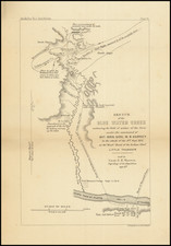
Fine 19th Century Chromolithograph of the Mormon Route from Nauvoo to Salt Lake
Marvelous panoramic map of the region between the Mississippi River and the Great Salt Lake, illustrating the overland trek of the Mormons in 1846 and 1847, which is drawn from Orson' Pratt's record of the trip.
Striking panoramic depiction of the mormon settlers route west from Illinois to Utah, 1846-1847. Seeking to escape harassment, the Mormons left their embattled settlement in Nauvoo, Illinois, in 1846, reaching their destination in the Valley of the Great Salt Lake a year later. This map charts the Saints progress across the midwest and plains with four vignettes showing a wagon train, a group of tepees, a buffalo herd, and numerous other scenes from the journey.. Each campsite along the route is noted with the dates where the emigrant party stayed at.
A remarkable depiction of one of the great episodes in American history, produced to commemorate the 50th anniversary of the journey. The present example is one of at least two states of the smaller version of the view, which was published by the Wilson Hotel in1899. The larger edition is approximately 42.5 x 14 inches: /gallery/detail/24593
![Mexico [Texas on the Eve of Independence]](https://storage.googleapis.com/raremaps/img/small/84917.jpg)
![Central Route to the Pacific, From The Valley of the Mississippi To California. Journal of The Expedition of E.F. Beale, Superintendant of Indian Affairs In California, And Gwinn Harris Heap, From Missouri To California [with map:] Map of the Central Route from the Valley of the Mississippi to California](https://storage.googleapis.com/raremaps/img/small/99222.jpg)