


|
||

|

|
|

|
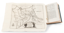
Rare French Map of the The Chespeake & Ohio Canal
Rare separately issued map showing the region between Washington, D.C. and Pittsburgh, published in connection with the construction of the Chesapeake & Ohio Canal.
The map was likely produced in connection with efforts to obtain financing for the canal from European investors.
The Chespeake & Ohio Canal
After the Revolutionary War, George Washington was the chief advocate of using waterways to connect the Eastern Seaboard to the Great Lakes and the Ohio River. In 1785, Washington founded the Potowmack Company to improve the navigability of the Potomac River. His company built five skirting canals around the major falls: Little Falls (later incorporated in the C&O Canal), Great Falls in Virginia, Seneca Falls (opposite Violette's lock), Payne's Falls of the Shenendoah, and House's Falls near Harpers Ferry. These canals allowed an easy downstream float; upstream journeys, propelled by pole, were harder.
With time, the Erie Canal, completed in 1825, threatened traders south of New York City, who began to seek their own transportation infrastructure to link the burgeoning areas west of the Appalachian Mountains to mid-Atlantic markets and ports. As early as 1820, plans were being laid for a canal to link the Ohio River and Chesapeake Bay.
In early March 1825, President James Monroe signed the bill chartering the construction of the C&O Canal as one of the last acts of his presidency. The plan was to build it in two sections, the eastern section from the tidewater of Washington, D.C., to Cumberland, Maryland; and the western section over the Allegheny Mountains to the Ohio River or one of its tributaries. Free from taxation, the canal company was required to have 100 miles in use in five years, and to complete the canal in 12 years. The canal was engineered to have a 2 mph water current, supplying the canal and assisting mules pulling boats downstream.
In October 23, 1826, the engineers submitted the study, presenting the proposed canal route in three sections. The eastern section comprised Georgetown to Cumberland; the middle section, Cumberland, going up Wills Creek to Hyndman then across the Sand Patch Grade crossing the Eastern Continental Divide to Garrett, to the confluence of the Casselman River and the Youghiogheny River; and the western section from there to Pittsburgh.
In 1824, the holdings of the "Patowmack Company" were ceded to the Chesapeake and Ohio Company. By 1825, the Canal Company was authorized by an act of the General Assembly of Maryland, in the amount of subscriptions of $500,000, authorized by the act of incorporation, which paved the way for future investments and loans. The Chesapeake and Ohio Canal Company was formally organized in June 1828.
The C&O's first chief engineer was Benjamin Wright, formerly chief engineer of the Erie Canal. A groundbreaking ceremony was held on July 4, 1828. At the groundbreaking, there was still argument over the eastern end of the canal. The directors thought that Little Falls (at the downstream end of the Patowmack Little Falls Skirting Canal) was sufficient since that literally fulfilled the charter's condition of reaching the tidewater, but people in Washington wanted it to end in Washington, connecting to the Tiber Creek and Anacostia river. For that reason, the canal originally opened from Little Falls to Seneca, and the next year, was extended down to Georgetown.
In November 1830, the canal opened from Little Falls to Seneca. The Georgetown section opened the following year.
Rarity
The map is very rare on the market. We locate only a single example in a dealer catalog in the past 30 years.
![[Pennsylvania, New Jersey, New York ] Speciel Land Charte von Pensilvanien, Neu Jersey, Neu York und von denen drey Land-schafften an dem Delaware Fl. In America in Englischer Spr. gedruckt A. 1749 In Europa duffgelegt in Teutsch Spr. zu Francfurt am M. A. 1750.](https://storage.googleapis.com/raremaps/img/small/51958.jpg)
![Military Map of Nebraska and Dakota by Lieut. G.K. Warren . . . [Second state]](https://storage.googleapis.com/raremaps/img/small/95390.jpg)