This item has been sold, but you can enter your email address to be notified if another example becomes available.


|
||

|

|
|

|
Stock# 45019
Description
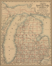
Scarce Charles Desliver map of Michigan, hand colored by county and showing towns, rivers, bays, lakes, railroads, roads, distances, etc. Tables of Steam Boat routes and distances.
A number of Michigan Counties still not yet formed. Railroads are shown in Red and Canals in Blue
A nice example of this increasing difficult to obtain map, from Thomas Cowperthwait's version of Mitchell's Universal Atlas.
An unsually clean fresh example.
![[Kensington Metropolitan Park / Kent Lake] Scouting To Adventure Gold Rush of '48 Detroit Area Council Boy Scouts of America . . . 1948](https://storage.googleapis.com/raremaps/img/small/63032.jpg)