|
||

|

|
|

|
William Lyon MacKenzie & The Upper Canada Rebellion
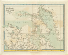
Rare separately issued broadside map of the Niagara River, between Lake Erie and Lake Ontario, illustrating William Lyon MacKenzie's activities in Upstate New York during the Upper Canada Rebellion.
The map provides a detailed treatment of the region, centered on Navy Island, with a note that the Island is 304 acres and the words "Mackenzie's Camp."
The Upper Canada Rebellion
The Upper Canada Rebellion was an insurrection against the oligarchic government of the British colony of Upper Canada in December 1837. While public grievances had existed for years, it was the Rebellion in Lower Canada that emboldened rebels in Upper Canada to openly revolt soon after.
The Upper Canada Rebellion was largely defeated shortly after it began, although resistance lingered until 1838, mainly through the support of the Hunters' Lodges, a secret anti-British, US-based militia that emerged around the Great Lakes. These rebels launched the Patriot War in 1838-39. The rebellion led directly to Lord Durham's Report on the Affairs of British North America and to The British North America Act, 1840 which partially reformed the British provinces into a unitary system.
One of the primary militant characters of the Rebellion was William Lyon Mackenzie (1795 - 1861), a Scottish-born Canadian and American journalist and politician. He was the first mayor of Toronto and was a leader during the 1837 Upper Canada Rebellion. Ultimately, he would lead and armed insurrection against the provincial authorities in December 1837, which was quickly put down.
The rebel leaders escaped to the United States, with Mackenzie arriving in Buffalo, New York on December 11, 1837. On December 12, he delivered an address to the largest public meeting in the history of Buffalo, describing Upper Canada's desire for liberty and their oppression at the hands of the British, and asking for their help. On December 13, he declared himself the head of a provisional government, entitled the "Republic of Canada". He devised a scheme whereby volunteers would invade Upper Canada from Navy Island in the Niagara River. Several hundred volunteers travelled to Navy Island in the next several weeks, as did shipments of food, arms, and cannon shot. Recruitment was hurt when President Martin Van Buren instructed the volunteers that they would be prosecuted as criminals if they participated in the planned invasion, and many volunteers returned home.
On December 29, Canadian volunteers led by Col. Allan MacNab bombarded Navy Island, while British troops led by Capt. Andrew Drew of the Royal Navy cut lose the American ship SS Caroline from its moorings and set it alight, as it had been supplying Navy Island. The action was undertaken based on information supplied by Alexander McLeod.
While this was going on, Mackenzie had travelled to Buffalo, seeking medical attention for his sick wife. While there, he was arrested for violating American neutrality laws, but was released on bail and returned to Navy Island in January. The Americans grew disillusioned, however, and on January 14, 1838, these volunteers withdrew from Navy Island to American soil whereupon they were arrested for being in breach of American neutrality.
The other major leaders, Van Egmond, Samuel Lount, and Peter Matthews were arrested by the British. Van Egmond died in prison, and Lount and Matthews were executed at 8 AM on April 12, 1838, in Toronto.
The rebels continued their raids into Canada, however, using the U.S. as a base of operations and cooperating with the U.S.Hunters' Lodges, dedicated to the overthrow of British rule in Canada. The raids did not end until the rebels and Hunters were decisively defeated at the Battle of the Windmill, nearly a year after the initial battle at Montgomery's Tavern.
The map is apparently very rare. We note no examples at auction or in dealer catalogs, other than the present example, which was part of a composite atlas offered for sale in 2015.
We located examples at the British Library, Library of Congress, John Carter Brown Library, Harvard and New York Public Library.
James Wyld Sr. (1790-1836) was a British cartographer and one of Europe’s leading mapmakers. He made many contributions to cartography, including the introduction of lithography into map printing in 1812.
William Faden, another celebrated cartographer, passed down his mapmaking business to Wyld in 1823. The quality and quantity of Faden’s maps, combined with Wyld’s considerable skill, brought Wyld great prestige.
Wyld was named geographer to Kings George IV and William IV, as well as HRH the Duke of York. In 1825, he was elected an Associate of the Institution of Civil Engineers. He was one of the founding members of the Royal Geographical Society in 1830. Also in 1830, his son, James Wyld Jr., took over his publishing house. Wyld Sr. died of overwork on October 14, 1836.
James Wyld Jr. (1812-87) was a renowned cartographer in his own right and he successfully carried on his father’s business. He gained the title of Geographer to the Queen and H.R.H. Prince Albert. Punch (1850) described him in humorous cartographic terms, “If Mr. Wyld’s brain should be ever discovered (we will be bound he has a Map of it inside his hat), we should like to have a peep at it, for we have a suspicion that the two hemispheres must be printed, varnished, and glazed, exactly like a pair of globes.”
![Carta rappresentante una parte della Baja Hudson, e le Regioni a Maestro dell'America Settentrle. [Map representing a part of Hudson Bay, and the regions to the northwest of North America.]](https://storage.googleapis.com/raremaps/img/small/95989.jpg)
![[Heightened with Gold] Paskaert Zynde de Noordelijckste Zeekusten van America van Groenland door de Straet Davis en de Straet Hudson tot Terra Neuf . . .](https://storage.googleapis.com/raremaps/img/small/83767.jpg)