|
||

|

|
|

|
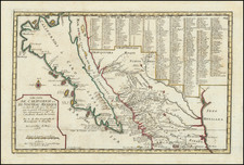
Proof State of the First Edition of William Jackson's Map of the Gold Regions of California.
The second recorded surviving example of William A. Jackson's seminal 1850 map of the California Gold Region, noted by Gary Kurutz as "as one of the best to cartographically describe the frenzy of the California Gold Rush. It stretches from the forks of the Feather River in the north to 'Rich Veins of Gold in Quartz' and the Mariposa River in the South, and records the great growth of mining in the first year of the gold rush."
This copy of the map has a very interesting feature. On the upper Yuba there is a small square drawn, indicating a location, and the name I.M. Wright. Bancroft's Pioneer Register lists a Wright, initials not specified, who was mining on the Yuba at this time. So, possibly this is a map owned by a forty-niner miner.
This first issue may be differentiated from the nearly equally rare second issue by being on heavier weight paper, and by the absence of the notation regarding quicksilver mines to the south of San Francisco. The only surviving example of this proof state is at the Library of Congress, where it was deposited as part of the copyright process.
The map provides a fine overview of the gold regions, extending from the southern mines on the "Mariposa River" (Mariposa Creek) to Grass Valley and Chico areas (not named), and centered on the Sacramento Delta and Gold Regions.
The map locates dozens of areas identified roughly 300 sights labeled as "Workings for Gold", as well as Indian Villages and towns. The Quicksilver mines south of Santa Clara are also shown, as are a number of the surviving Missions. The map also provides a fine overview of the existing roads, including some distance numbers.
The "Workings for Gold" are primarily concentrated on the following Rivers (and their upper tributaries):
- Mariposa River
- Mercedes (Merced) River
- Tuoleme (Tuolumne) River
- Stanislaus River
- Calaveras River
- Mokelome (Moklumne) River
- Cosumes (Cosumnes) River
- Bear River
- Yuba River
- Feather River
- American River
First edition, State 2 of Jackson Map: www.digitalcommonwealth.org/search/commonwealth:4m90fc37g
Second edition of Jackson Map: www.raremaps.com/gallery/detail/23821
An extremely rare and important map, chronologically the fourth to be printed showing the gold region. Wheat describes it as "an excellent early map [which] includes all of the important diggings of 1849 and early 1850." The map indicates the rapid growth of roads and trails, and of bars and diggings, some of the latter being named for the first time (Murphy's, Angel's, Jamestown, Sonoranian Camp, Hawkins Bar, Double Springs, Nye's Ferry, and Jacksonville). . . . The Ellis map of 1850, published later in the year, was based upon the Jackson map, of which a second, revised edition appeared in 1851.
Streeter dates the Jackson map as no earlier than February 1850, stating:
The Jackson map, which extends from below the Mariposa River on the south to a little above the 39 1/2 parallel on the north, is, I believe, by far the best of the maps of the gold region published to that time. It is on the large scale of about nine miles to the inch, and is skillfully drawn, showing the rivers and roads clearly and indicating a great number of separate mining districts. As the text of the Appendix is dated at the beginning "California, Dec. 1849" and at the end on p. 12, "Dec. 30, 1849," it could hardly have been published in New York until some time in February, 1850.
Proof State with Annotations.
The present example has been trimmed at the left side and bottom side, apparently at or shortly after the time of printing. We strongly surmise that the cuts were made by the publisher, it is clear from the offsetting of the title that at the time the map was first folded, it had already been trimmed. We suspect that the map was trimmed either because it was a early proof pull not intended for resale or was trimmed for the same reason after the copyright was secured. Nevertheless, as one of the first printed maps to provide some semblance of observational accuracy, it was clearly acquired at a relatively early point in time and used, as noted by the folds and the manuscript addition of the name I.M. Wright.
Provenance: Warren Heckrotte Collection, sold by PBA in December 2015.
![[First Obtainable Map to Name California] Tartariae Sive Magni Chami Regni typus](https://storage.googleapis.com/raremaps/img/small/82510.jpg)
![California [with large inset of Utah and Part of New Mexico]](https://storage.googleapis.com/raremaps/img/small/92004.jpg)