


|
||

|

|
|

|
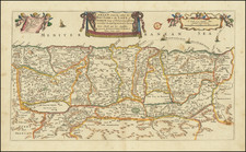
Rare Map of the Holy Land
Fine example of Michael van Lochem's map of the Holy Land, published in Paris cira 1640.
The map is loosely based upon Ortelius' Terra Sancta, although the graphics and engraving style are very different than the more comon map by Ortelius. Ortelius drew his map from a 9 sheet map of Palestine by Christian Sgrothen (Christian Schrot), published around 1570, which in turn was based on cartographical sources collected by the Dutch astronomer, Petrus Laiksteen, during his visit to the Holy Land in 1566.
Shows the shore line from Beirut to Gaza. The shore line is distorted by many fanciful bays and promontories. Wide meanderings of the River Jordan are also quite fanciful at best. The map is oriented with the north to the left.
The Van Lochem map is extremely rare. OCLC locates only one example in the National Library of Israel - Jewish National Library.
![[Cyprus, Holy Land, Syria Middle East] Tabula Asiae IIII](https://storage.googleapis.com/raremaps/img/small/100937.jpg)
![[Untitled Map of the Holy Land]](https://storage.googleapis.com/raremaps/img/small/87770.jpg)