


|
||

|

|
|

|
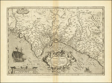
First state of De Jode's rare map of Spain & Portugal.
Fine example of De Jode's rare map of Spain & Portugal, from his Speculum Orbis Terrarum, the second modern World Atlas.
The map was engraved by Joannes and Lucas Van Deutecum and includes sea monsters, sailing ships and an ornate coat of arms.
De Jode's map of the Iberian Peninsula is one of the earliest obtainable maps of Spain, published in the Low Countries. The map gives credit to the Neapolitan Artist and Antiquarian, Pirro Ligorio, as the author of the map. This is undoubtedly a reference to Michele and Franceso Tramezzini's Nova Totius Hispaniae Descriptio, published in Rome in 1559. Although the Papal privilege for the map was apparently not granted to the publishers until Febraury 3, 1560, one of 4 maps by the Tramezzini granted a privilege on that date, the others being Ligorio's maps of Ancient Rome and Greece (Vedrai Divisi i Termini di Tutta la Grecia), as well as Hungary).
The History of the Modern Mapping of Spain & Portugal
The earliest non-Ptolemy based printed map of Iberia is Berlingheri's Hispania Novella, published in Berlingheri's edition of Ptolemy's Geography. This map was copied in the Ulm (1482), Rome (1507), Waldseemuller (1513), Fries (1522) and Munster (1540) editions of Ptolemy. However, the source for Berlingheri's map has been described by the eminent cartographic scholar Leo Bagrow as unknown.
While Royally commissioned systematic survey of Spain was attempted as early as 1517 by the King of Spain, who commissioned Christopher Columbus' son Fernan Colon to undertake this work as part of a description and cosmography of Spain, no separate map was published as part of this work. The earliest printed map of the Iberian Peninsula, not based upon Berlingheri's map, was published by G.A. Vavassore in Venice in 1532. While the source of Vavassore's map is not known with certainty, it is generally attributed to the work of Vincentus Corsulensis. Matheo Pagano created an early copy of the map, although no example is known to survive. The next map of Iberia was published by Eneo Vico in 1542, a map which was thereafter copied by a number of other publishers in 1544.
The first large format widely disbursed map of Spain was the 4 sheet map created by Giacomo Gastaldi in 1544, Gastaldi's earliest known map. Gastaldi, who was unquestionably the most important map publisher of his time, credited source material received from Don Diego Hurtado de Mendoza, then serving as Carlos V's Ambassador to Venice, as the source for the map.
A number of other mapmakers drew upon the Corsulensis model. These include the maps of Hieronomus Cock (1553), Paolo Forlani (1560) and Henricus Van Schoel (Camocio), 1602.
Flemish mapmaker Thomas Geminus (then resident in London) published a 4-sheet map of Spain in 1555, the earliest map of Spain published in England. Geminus' map was in turn copied by in maps done in Rome in 1559, by Pirro Ligorio (engraved and published by Tramezzini), and a 2 sheet map by Vincenzo Luchini.
The last of the major 16th Spain was compiled by the French Botanist Charles de l'Escluse (Carolus Clusius), whose map was compiled and printed on 6 sheets by Abraham Ortelius in 1570 and later re-issued in Paris in 1606 and 1696. Hessel Gerritsz also created a monumental wall map of Iberia in 1612, which was engraved and printed in 1615.
![[ Madeira ] Carte Des Isles De Madere Et Porto Santo](https://storage.googleapis.com/raremaps/img/small/101865.jpg)