|
||

|

|
|

|
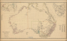
Fine example of the 1816 state of Walch' map of Australasia and the South Pacific, first published in Augsburg in 1802.
The map provides a tremendous number of place names in Australia, New Zealand and throughout the map, and includes the tracks of the voyages of Tasman, Cook, Marshall, Bougainville, Carteret, Byron, etc., including dates.
Many of the islands shown in detail, along with the tracks of Cook, Byron and Carteret.. This map was also later republished in 1820, 1824 & 1826, with amendments. The regions of Neu Holland include De Witt's Land, Edel's Land, Dinngs Land, Endracht Land, Lowens Land and P. Nuyt's Land, along the Western coastline.
New Zealand is shown as two islands, utilizing the Maori names for the two islands.
Johann, or Johannes, Walch (1757-1816) was a painter and engraver. He was well-known for painting miniature portraits, having trained in Geneva, Venice, and Rome. Walch published several atlases and sheet maps. As with his atlases, many of Walch’s maps were reprinted after his death.