


|
||

|

|
|

|
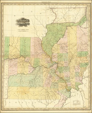
One of The Best Maps of Michigan in the Period Immediately After Statehood.
The present map was first issued in 1837 and continued to be offered until 1855. Focusing in on the part of Michigan surveyed by the General Land Office, the map provides a remarkable look at the hydrographical features of the unsettled regions in the northwestern part of the the map, along with the early counties. In the south, the earliest roads and towns are shown.
John Farmer's maps of Michigan are among the earliest maps of Michigan and are highly sought after among collectors.
Farmer was born in Half Moon, NY in 1798, educated near Albany and taught at the Lancastrian School in Albany. He relocated to Michigan in 1821 at the invitation of Governor Cass and the Trustees of the University of Michigan. He engaged in extensive survey work and published his first map of Michigan in 1826. Over the next 5 years, he was responsible for a total of 12 maps, many of which he engraved himself, including the first map of Detroit.
Farmer's early maps were largely influential in promoting the extensive emigration to Michigan that occurred between 1825 and 1840.
The present map was first issued in 1837 and re-issued in 1839, 1840 and 1845. All examples are rare on the market. We note only a single example in a dealer catalog in the past 30 years (1840 edition) and one example at auction in the past 60 years (per RareBookHub.com, 1837 edition).
John Farmer first became a school teacher and taught map drafting among other topics in upstate New York.
At the time, Michigan Territory was in need of teachers. In December 1821 the board of University of Michigan in Detroit (still only primary and secondary education) offered Farmer a position as head of the Lancasterian School.
Trained as a draftsman, Farmer supplemented his income by copying surveyor's township maps and selling the maps to new settlers. He also drew for the Treasurer of the United States a map of Michigan’s first real road, which had been funded by the federal government and assisted Orange Risdon in his map of the surveyed part of Michigan. When Risdon’s project stalled, Farmer ended up publishing his own detailed map of the state in 1826.
By 1830, Farmer had created a new large format map of Michigan which had so much detail that the engraving of the map had to be outsourced to engravers in New York City. This Map of the Surveyed Part of the State of Michigan depicts in great detail the southern half of Michigan’s lower peninsula.
Farmer also produced regional maps starting in 1835 when both Michigan and Wisconsin were still mere territories, ontinuously revising them over the years to reflect changes in development. At the time of his death nearly 25 years later he was still producing a Michigan & Wisconsin map, now titled Map of the States of Michigan and Wisconsin, embracing a great part of Iowa and Illinois and the whole mineral region with a chart of the lakes: Exhibiting the sections, the geological formations, and the general topography.
After a few years Farmer sold the publishing rights to his maps to eastern publisher J. H. Colton and turned his attention to mapping new communities and became involved in the formation of a Detroit Board of School Inspectors.
In 1844, Farmer issued the first edition of his The State of Michigan and the Surrounding Country. This map contained extreme detail of every surveyed square mile, every stream, swamp, and every road and trail and would be published by the Farmer family for the next 30 years.
Farmer died March 24, 1859 in Detroit, Michigan. His widow Rachel Farmer and sons Silas, Arthur and John carried on the business for some time afterward. Maps published after John Farmer's death, however, never maintained the detail and currency of his former work.
![(Upper Louisiana / Missouri) [Manuscript document: an agreement to sell a keel boat between Abner McCourtnay and Hubbard & Hertich, both of Sainte Genevieve, Territory of Upper Louisiana, 9 April 1812] Memorandum of an agreement...](https://storage.googleapis.com/raremaps/img/small/96184.jpg)
