|
||

|

|
|

|
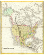
The Pacific Northwest as Colombia!
Marvelous map of North America, in the decade following publication of Lewis & Clark's seminal map of the Northwest.
Very early appearance of the 54-40 or fight Oregon Territorial boundary. Russian America appears in the Polar regions, as does a region referred to as Nouveau Cornouilles. The limits of Mackenzie, Franklin and Hearn's expeditions are noted, with dates showing the years of exploration. Excellent detail in the Bering Straits for the period.
In the United States, the details for the explorations of Lewis & Clark are noted, along with a detailed treatment of the recently created Missouri Territory, which encompasses all of the former Louisiana territory, except for the newly created states of Louisiana and Mississippi. Texas and Upper California are still part of the newly independent Mexico, with a number of early California, New Mexio and Texas place names given, as well as a detailed treatment of the Rio Grand to beyond Santa Fe and Taos.
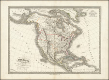
The first edition of the map, which would appear in Vivien St. Martin's Atlas Universel for the next decade.