|
||

|

|
|

|
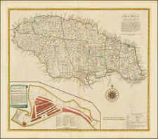
Extremely Rare Early Separately Published English Map of Jamaica.
Fine detailed map of Jamaica, published by George Foster in London in 1740, one of the earliest maps of Jamaica published in England.
The map provides a meticulous account of Jamaica, with different symbols showing Towns, Churches, Sugar Works, Indico Works, Cotton & Provisions, "A Cacao Walk," and Crawles for Hogs & Pens for Cattle.
The map is colored by counties and shows the various Parishes within the island, along with a large inset map of Port Royal Harbor.
The map is exceedingly rare, this being the first example to appear on the market which we could locate, dating back over 50 years.
OCLC lists examples at the John Carter Brown, British Library (King George IV Collection) and Bibliotheque Nationale de France. The map also appears in the Catalogue of the Library of Harvard University in 1831. Not listed in Bibliographia jamaicensis. . .
![La Jamaique aux Anglois dans le Golfe du Mexique [and] La Bermude aux Anglois](https://storage.googleapis.com/raremaps/img/small/99605.jpg)
![Cuba Insula [with] Hispaniola Insula [with] Ins. Jamaica [with] Ins. S. Ioannis [with] I.S. Margareta [with] Havana portus](https://storage.googleapis.com/raremaps/img/small/95302.jpg)
![[Jamaica & Cuba] Carte Reduite De L'Isle De La Jamaique pour servir aux Vaisseaux Français . . . 1753](https://storage.googleapis.com/raremaps/img/small/79971.jpg)