|
||

|

|
|

|
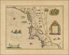
One of the earliest obtainable Sea Charts of the Atlantic Coast of North America.
Important early Dutch sea chart of the coast of North America from Trinity Harbor, North Carolina to Cape St. Ann, Massachusetts, from Doncker's Zee-atlas ofte water-waereld, first published in Amsterdam in 1660.
Doncker's chart is the third Dutch sea chart of the region, preceded only by Theunis Jacobs z' virtually unobtainable Pascaerte van Nieu Nederlant Virginies, Nieu Engelant en Nova Francia . . . (circa 1650) and Arnold Colom's rare Pascaarte van Nieu Nederlandt . . . (1656). Burden states:
The map is largely derived from Colom's chart, although with some omissions and additions. The key to the various names of the Hudson River is left out, as is the duplicate use of Jamestown. Amongst the new nomenclature can be found Gilfort on the north shore of Long Island Sound. The coastline is virtually identical, with the exception of that part south of Cape Henry, where at first glance he appeared to draw upon Jacobsz, until one notices Chesipioock at the northern end of the Outer Banks. This usage dates back to those derived from the De Bry--White map of 1590 . . . .
Doncker's chart includes rhumb lines, compass rose, location of estuaries, settlements, sea banks or shoals, and Indian tribes. The decorative cartouche includes native American man and woman, with sailing ships off the coast. This is the first edition of the map, which can be identified by the inclusion of the date (1660) in the cartouche. A second edition was published in Doncker's Atlas in 1670. A third edition was published in 1680, with the plate heavily reworked and the addition of a title in English and new coastlines.
The map is one of two charts of the region issued by Doncker, who also issued the 4th and 5th editions of Arnold Colom's 1656 Pascaarte van Nieu Nederlandt . . . in 1670 and 1676 respectively, both of which were separately published and would also have been bound into composite atlases of the period.
Hendrik Doncker was a famous bookseller in Amsterdam, who started at the age of 22 years and ran his shop successfully for fifty years. He published his first sea atlas around 1659. Due to the fact that Hendrik Doncker corrected and improved his charts more frequently then his competitors, his business was quite successful and there was a high demand for his works and this reflected also the various improved and corrected editions of sea atlases he published. This map was published in a composite sea atlas by Pieter Goos, who was 'one of the best known maritime booksellers of Amsterdam' (Koeman), he published a number of different sea-atlases or pilot books, his work was very much derivative. With his 'Zee-Atlas' he relied heavily on Hendrick Doncker's 'Zee-Atlas' of 1659.
Hendrik Doncker was a prominent bookseller in Amsterdam best known for his sea charts and nautical atlases. He issued his own original charts, which he updated frequently, and also worked with colleagues like Pieter Goos, for example to produce the pilot guide, De Zeespeigel. He died in 1699, after fifty years in business. His plates then passed to Johannes van Keulen.