


|
||

|

|
|

|
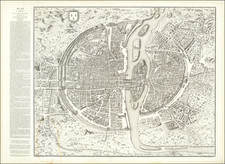
This is Dheulland's historical view of Paris, a fascinating mid-18th century piece showing the city as it stood during the reign of Charles IX, that is, sometime between 1560 and 1574. Published in Paris in 1766, this map reflects upon the Medieval layout of the great city of Paris, based on an early post-medieval wall hanging in the Abbey of Saint-Victor.
The map is centered on the Seine River, with fortified walls of the town barely extending beyond the Isle St. Louis. Individual buildings are shown throughout, with roads and streets named. Places that are now considered major landmarks of the city, such as Les Gobelins, are well outside of the city center. The only bridges in Paris are those connecting the Isle St. Louis to the left and right banks, with one new bridge apparently under construction. These bridges are all lined with houses, reminiscent of the Medieval layout of the city. Numerous fascinating images appear throughout the map, with a wooden tower next to the Louvre, but no "Porte Neuve" yet.
The text at the left details the history of the city and the layout during the 16th-century, the time during which the map purports to show. Excerpts from the description read as follows:
This ancient plan of Paris that we give is strictly copied from an engraved plan in the Library of St. Victor that we believe to be unique. The Dons of Saint Victor, in sight of the public good, have not wanted to be the only owners of this plan and have consented with happiness to have it copied. This plan is also the same that is represented on a tapestry that was formerly owned by the House of Guyse, of which the City recently made acquisition under the Prevost of Mr. Turgot.
The text suggests that there are several clues which can aid the definite identification of the dating of the map, among them the following:
- The presence of two small islands just downstream of the Isle de la Cite.
- The Isle de St. Louis is divided into two islands
- The course of the Gobellins River maintains its path from pre-Louis le Jeune times
- The Hotel de Nesle is extant with its long galleries
![(France, Belgium, and Holland) Tabula Moderna Francie [Modern Map of France]](https://storage.googleapis.com/raremaps/img/small/101885.jpg)
![(Atlas of France) Les Cartes Generales de Toutes les Provinces de France Reveues corrigees & augmentees par le Sr. Tassin Geographe ordinaire de sa Mageste [The General Maps of All the Provinces of France, Reviewed, Corrected, and Expanded by Mr. Tassin, Geographer to His Majesty.]](https://storage.googleapis.com/raremaps/img/small/95902.jpg)