


|
||

|

|
|

|
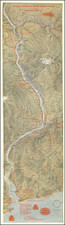
Striking map of the Columbia River Valley from John Day River and the Wasco area to the Pacific, centered on Portand.
The map displays topographical relief, along with rivers, roads, railroad lines and the course of the Columbia River and many of its tributaries.
In red, the map also includes many important historical locations and dates, including a day by day account of Lewis & Clark's expedition in the area in 1805 and again in 1806. In addition to the Lewis & Clark information, the following are shown:
- John Jacob Astor 's arrival in 1811 and 1812.
- Lt. Philip Sheridan
- Lt. W.R. Broughton's expedition up the Columbia in October and November of 1792
- Captain Robert Gray's expedition up the Columbia in May 1792
- Ft. Vancouver (1825)
- Founding of Portland in 1844
Fred Routledge (1871-1936) was an Oregon artist and pictorial mapmaker, who spent much of his professional life as a correspondent for the Morning Oregonian. His career lasted from the 1890s to the early 1930s. Routledge was a well regarded artist, who received awards for his paintings, including a first prize at the 1915 Panama-Pacific Exposition in San Francisco. His ephemeral work as a pictorial cartographer was also very well regarded.
Routledge was born in Abilene, Kansas, raised in Rockford, Illinois, and settled in the Portland area in 1886 with his family. He began working as an illustrator with the West Shore publication before its demise in 1891, thereafter finding wor at the Oregonian in 1895. The January 1, 1896 "Where Rolls the Oregon," is his first work of significant note.