


|
||

|

|
|

|
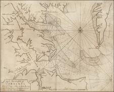
The First Printed Map of Virginia and the Carolinas -- And The Earliest Regional Map To Show The English Roanoke Colony
John White's manuscript of Virginia, engraved by De Bry for his Anglorum in Virginiam aduentus, is one of the most significant cartographic milestones in colonial North American history.
Theodore de Bry's map of Virginia, after John White, is one of the most significant cartographical milestones in colonial North American history. It was the most accurate map drawn in the sixteenth century of any part of that continent. It became the prototype of the area long after James Moxon's map in 1671. The region of Chesapeake Bay was, however, improved by the surveying of John Smith around 1607. This is the first map to focus on Virginia (now largely North Carolina), and records the first English attempts at colonization in the New World.
Burden states
The map concerned depicts the area from Chesapeake Bay to Cape Lookout. It exhibits greater knowledge than on any of the surviving manuscripts. Possibly this is from knowledge gained during White's brief visit in 1587 and signifies some lost manuscripts. Here we find the first printed use of the name Chesapeake, Chesepiooc Sinus, and the second of Roanoke (the first being Mazza). It depicts the positions of the Indian villages in the area and is adorned with the Royal Arms of England. The Latter's ships are shown at sea with Indian canoes traversing the inland waters. The two native scenes shown are taken from illustrations in the book. It influenced many maps, most notably those of de Jode 1593, Wytfliet 1597 and Metellus 1598. There are three states of the map, this is the second one with a 'C' superimposed on the first letter of the village called Ehesepiooc
Cumming comments
Although this map lacks the authenticity of White's manuscript map of approximately the same area, the addition of some names and an improvement in coastal delineation may show increased knowledge gaines in 1587-88, after the manuscript map was made. De Bry's engraving of White's watercolor map is one of the most important type maps in Carolina cartography.
Stephenson & McKee state:
The new geographical information imparted by the White-de Bry engraving swept through Europe and was incorporated into maps by other publishers for at least eighty years. Roanoke Island, neighboring Indian villages, and other features are identified. In addition, the entrance to the Chesapeake Bay, Chesepiooc Sinus, is named for the first time on a published map. De Bry oriented White's map to show west at the top rather than north. This became the preferred orientation for published maps of Virginia and other eastern seaboard colonies until the eighteenth century.
English attempts to colonize the east coast of North America began with Watler Raleigh's dispatch of Captains Philip Amadas and Arthy Barlow in 1584. The party selected Roanoake Island and returned to England. In April 1585, a colonization expedition was dispatched to the newly named colony of Virginia, led by Sir Richard Grenville. A fort was constructed and small parties sent out to explore the area, including scientist and surveyor Thomas Hariot and the artist John White. White sketched a number of drawings, and with Harriot began preparation of a manuscript map of the areas visited. The Roanoake Colony failed and Sir Francis Drake took home the surviving colonists in June 1586. Grenville returned later that summer, leaving a party of 15 men, who did not survive .
A fourth voyage was made in July 1587, with White, by then Colonial Governor, undertaking the restoration of the Colony. White returned to England to seek more provisions and by the time he returned to the Roanoke Colony, in 1590, it had again been decimated, with no survivors. In order to keep the colonial efforts moving forward, Thomas Harriot published A briefe and true report of the new found land of Virginia in 1588. Theodore De Bry, was in London in 1590 trying to acquire Le Moyne's original drawings from the French attempt to colonize Florida in the 1560s, However, he was persuaded instead to publish Harrot's account, illustrated with White's drawings.
De Bry's edition of Harriot's 1588 account of Virginia was first published in Frankfurt in 1590, and ultimately published in 4 languages (Latin, German, French & English). The English and French editions are tremendous rarities. Later editions of the book were published in 1608 (Latin), 1600 and 1620 (German). A 1634 edition was published by Merian, but apparently without the map.
An essential antique map for Virginia and Carolina Collectors.

![[ Port Royal, South Carolina ]](https://storage.googleapis.com/raremaps/img/small/81298.jpg)
![Map of the States of North & South Carolina [Large Charleston Inset]](https://storage.googleapis.com/raremaps/img/small/91846.jpg)
![[ Pictish Man Holding Severed Head ] Picti icon](https://storage.googleapis.com/raremaps/img/small/99837.jpg)