


|
||

|

|
|

|
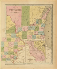
Early edition of Bradford's early map of part of Iowa and Wisconsin, with large inset showing all of Iowa Territory and Wisconsin Territory extending to the Canadian Border.
This edition shows very early counties configurations and geographical detail in both Wisconsin and Iowa.
The map would be significantly updated and revised in the 1846 edition, illustrated here: /gallery/detail/24448
Iowa Territory was organized in July 1838 and remained a Territory until 1846. Most of the part of Iowa shown is Indian Lands, with only Dubque, Cook, Musqueti, Louisa, Herny, Des Moines, Lee, and Van Buren Counties shown. Wisconsin also has only a handful of counties, all but Crawford being south of the Wisconsin River. The Lands to the North include New York Indian Lands. Massive Iowa and Brown Counties are shown. Many early forts, rapids, portages, etc. are shown. This is the second edition of the map, with the edition being the first appearance of Iowa on a commercial atlas map Similarly, Wisconsin had only become a territory in July 1836, with the first edition again being the first appearance in a commercial atlas.
The inset tracks the drainage of the Missouri River to Canada and shows many Indian Tribal lands, forts etc. Bradford's Illustrated Atlas was first issued in 1838.
Thomas Gamaliel Bradford (1802-1887) was an American geographic publisher. He hailed from Bradford, Massachusetts and began his publishing career by working for the America Encyclopedia. Then, he edited and republished the Atlas Designed to Illustrate the Abridgement of Universal Geography, Modern & Ancient, which had originally been offered in French by Adrian Balbi. In 1835, he published another atlas, A Comprehensive Atlas: Geographical, Historical & Commercial, and, in 1838, An Illustrated Atlas Geographical, Statistical and Historical of the United States and Adjacent Countries. His interests were primarily in educational publishing and he was one of the first mapmakers to show Texas as an independent country.
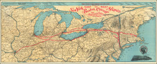
![[Carolinas, Virginia, the Chesapeake, Pennsylvania, New York]](https://storage.googleapis.com/raremaps/img/small/71479.jpg)

![Mapa et tierra q[u]e yos pedro Vial taigo transitau en St. Tafee este dia 18 de Octubre de La ao 1787](https://storage.googleapis.com/raremaps/img/small/3645.jpg)