|
||

|

|
|

|
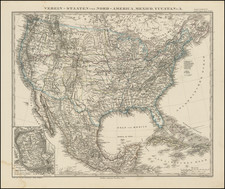
Rare Large Educational Map, With Pictorial Map Illustrating French Exploration of America and Illustrated Historical Chart of the United States.
Decorative large format image, printed in color on both sides, almost certainly for educational purposes.
French Explorers
The map side includes an illustrated overview of the French explorations of Great Lakes and the Mississippi River Valley, between 1669 and 1687. The focal point of the map are the exploits of the following explorers:
- Mackinaw (1669)
- Jacques Marquette & Louis Joliet (1673)
- Louis Hennepin (1680)
- Rene-Robert Cavelier, Sieur de La Sale (1669-1687)
Below the map is a more detailed time line of the French Explorers and history of North America from 1493 to 1682.
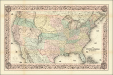
Organization and Development
This non-map side includes numerous vignettes of important American Events and Presidents.
The text consists of an overview on the organization of the Federal Government, along with a history of the Presidencies from Washington to William Henry Harrison, with major events during each presidency noted, concluding with the US Annexation of Texas during the Harrison administration of 1841-1845.