|
||

|

|
|

|
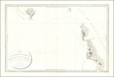
Scarce chart of the Western Pacific Ocean, published by Mortier, Covens & Fils.
The map is based on Johann Matthias Christoph Reinecke's 1801 map of the region, which was the first German map to depict Tasmania as a separate island. The Mortier Covens & Fils edition includes a translation of many place names into French and Dutch.
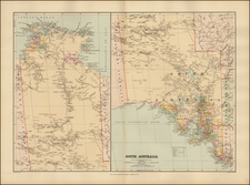
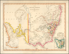
Australia is divided with the western portion named Nouvelle Hollande (New Holland) and the eastern portion named Nouveau Galles Meridionale ou Sijdnij Cove (New South Wales or Sydney Cove). Numerous placenames fill the coasts of Australia, which is depicted with a hypothetical coastline stretching from Western Port to St. Peters Island.
Dozens of tiny islands in the Pacific are named, including Hawaii (Iles Sandwich), which appears adjacent to the title cartouche. Several areas still show very early cartography, including Korea shown in a trapezoidal shape, and New Guinea with an elongated shape and a hypothetical northeastern coastline.
Engraved by Willem Cornelius van Baarsel, who was only 17 at the time of publication.
Covens & Mortier was one of the largest and most successful publishing firms in Dutch history and continued in business for over a century. Pierre Mortier the Elder (1661-1711) had obtained a privilege in 1690 to distribute the works of French geographers in the Netherlands. After his widow continued the business for several years, Cornelis (1699-1783) took over in 1719.
In 1721, Mortier forged a partnership with Johannes Covens (1697-1774), who had recently married Cornelis’ sister. They published under the joint name of Covens & Mortier. Johannes continued to work with Cornelis’ heirs after his death. In 1774, upon the death of his father, Johannes Covens II (1722-1794) took over his father’s share. In 1778, the company changed its name to J. Covens & Zoon, or J. Covens & Son.
Covens II’s son, Cornelis (1764-1825), later inherited the business and brought Petrus Mortier IV back into the fold. Petrus was the great-grandson of Petrus Mortier I. From 1794, the business was called Mortier, Covens & Zoon, or Mortier, Covens, & Son.
The business specialized in publishing French geographers including Deslisle, Jaillot, Janssonius, and Sanson. They also published atlases, for example a 1725 reissue of Frederik de Wit’s Atlas Major and an atlas, with additions, from the works of Guillaume Delisle. There were also Covens & Mortier pocket atlases and town atlases. The company profited from acquiring plates from other geographers as well. For example, the purchased Pieter van der Aa’s plates in 1730. Finally, they also compiled a few maps in house. At their height, they had the largest collection of geographic prints ever assembled in Amsterdam.
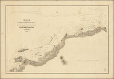
![[Vancouver in Australia] Partie De La Cote Sud-Ouest de la Nouvelle Hollande abec les Routes de la Corvette la Decouverte et sa conserve le Chatham comandes par Georges Vancouver en l'Anee 1791](https://storage.googleapis.com/raremaps/img/small/87867.jpg)