|
||

|

|
|

|
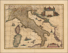
Decorative regional map, centered on Rome and includes two large attractive cartouches, ships an sea and decorative lettering.
The map extends from Orvieto to Narni and Turni, to Veroli an Fondi and Gaeta, tracking the coastline of Campagna and Suburbicaria and showing a large portion of Tuscany. Several sailing ships and sea monsters in the water. Several minor plate cracks, but the map itself is a fine example with wide full margins. Fascinating example of the printed art and the duration of use of the copperplates which produced these maps.
Pierre, or Pieter, Mortier (1661-1711) was a Dutch engraver, son of a French refugee. He was born in Leiden. In 1690 he was granted a privilege to publish French maps in Dutch lands. In 1693 he released the first and accompanying volume of the Neptune Francois. The third followed in 1700. His son, Cornelis (1699-1783), would partner with Johannes Covens I, creating one of the most important map publishing companies of the eighteenth century.
![Italia '90 14-й чемпионат мира по футболу. [FIFA World Cup]](https://storage.googleapis.com/raremaps/img/small/89590.jpg)